


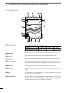

48
1
rSOUNDER MODEq AVAILABLE SCREENS AND INDICATIONS
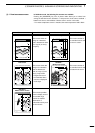
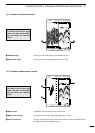
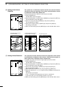
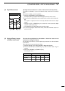
(1)-6 Standard + Marker zoom-in screen
Underwater area around this marker is zoomed in.
This image covers the specified underwater area (☞ P. 55).
This line represents the center of the marker zoom-in image and corresponds to
the depth marker on the standard image.
H
2
1
3
4
5
0
3
4
2
1
5
GPS 48°21.417N 125°26.643W
x
z
c
19.5
FT
43.4
315
°T
10
.
2KT 58°F
20
40
60
80
0
100
z Depth marker
x Maker zoom-in image
c Zoom-in centerline
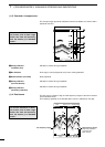
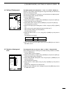
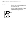
This image is the same as that on the standard screen.
This image covers the specified bottom area (☞ P. 54).
z Standard image
x Bottom lock image
(1)-5 Standard + Bottom lock screen
0
10
5
H
FT
57.6
315
°T
10
.
2KT 58°F
GPS 48°21.417N 125°26.643W
z
x
20
40
60
80
0
100
For common indications on differ-
ent screens, such as alarm range
marker, time mark and sensitivity
level, see section (1)-2 “Standard
screen”.
For common indications on differ-
ent screens, such as alarm range
marker, time mark and sensitivity
level, see section (1)-2 “Standard
screen”.