


___________ For
example, suppose you
are anchored at a location that is
accurately
However,
situations occur
where it becomes
necessary
to increase or
decrease the
sensitivity.
This
typically happens
when
you
wish to see
more
detail,
so
an
increase
in
sensitivity
is indicated. The
procedure
to
adjust
it is the same whetherthe unit is in the
automatic or manual mode.
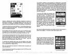
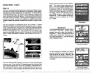
To
adjust
the
sensitivity, press
the SENS
key.
The
sensitivity adjust
menu
appears
on the left side of the screen. The switch forthe
Grayline adjust
menu is
immediately
beneath
it.
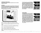
The
sensitivity
menu has
up
and
down
arrows,
plus
a vertical bar
graph.
The
graph gives
a visual indication of
the
sensitivity
level. The number
above the
up
arrow also shows the
percentage
of
sensitivity
in use.
marked on
a chart. Your UltraNavGPS
displays
a
longitude position
that is
.010
degrees
less than the one on the chart.
Using
the Position Correction
Factor
(PCF)
Offset
feature,
you
make the UltraNavGPS read the same as
the
chart.
If
you
raise anchor and
move,
the UltraNavGPS will add the
change you
made to all
positions.
This makes it more
closely
match the
datum used
by
the chart. For this
reason,
you
should be careful when
entering
the PCF Offset. This is saved in
memory.
It does not
change
when
the unit is turned off.
To use the PCF
Offset,
first subtract
your
current
position
from the location on the chart
you
wish to match. For
example,
if
your
location is N 32°1
0.220',
W80°1 2.106' andthe
chart's
position
is N 32°1
5.604',
W080°1
2.714',
then the
position
offset is N
00°05.384',
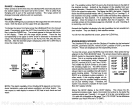
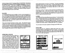
W 00°00.608'. Press the MENU
key,
then
press
the
key adjacent
to the 'CHANGE
SETUP" label. Now
press
the
key adjacent
to
the "MORE" label until the "ENTER PCF
OFFSET" label
appears.
Press the
key adja-
cent to that label. The screen shown at
right
appears.
r
Now enter the difference between
your position
and the chart's location in
latitude and
longitude.
The screen shown below
appears
next.
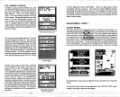
To increase the
sensitivity
level,
press
the
key adjacent
to the menu's
up
arrow on the left side of the unit. As
you press
the
key,
the menu's bar
graph
will
grow
taller and the
percentage
will increase in value. You can
also see the difference on the chart record as it scrolls. When the
sensitivity
is at the desired
level,
release the
key.
To decrease the
sensitivity
level,
press
the
key adjacent
to the down
arrow. The
bargraph
and
percentage
will decrease. When the
sensitivity
is at the desired
level,
release the
key.
When
you
reach either the maximum or minimum
limit,
the
speaker
will
sound an alert tone.
To turn the menus
off,
press
the
key adjacent
to the CLEAR
key
at the
bottom left side of the unit.
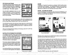
Press the
keys adjacent
to the N/S or E/W
Toggle
labels to switch the latitude and
longitudetosouthoreast, respectively.
When
the
position
at the
top
of the screen is
correct,
press
the
key adjacent
to the "Fin-
ished" label. The UltraNavGPS now adds
the correction factor to all
position displays.
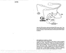
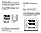
ra
N'S TOGGLE
W'E TOGGLE
2nd PCF ENTRY SCREEN
10
63
q3•3rT
-20
ec
e
04
GRAY
I
U
•aa.iaa
N
— 0_ —
-
—— —
U———0——.
JSE NUMBERED
KEYS TO
INPUT YOUR
OFFSET
POSITION
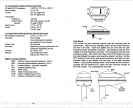
itt PCF ENTRY SCREEN
N 00005334
LI000°0O.603
-
FINISHED
PDF compression, OCR, web-optimization with CVISION's PdfCompressor