


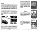
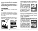
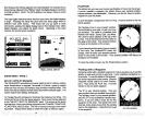
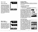

Now
simply press
the
key adjacent
to the desired label. For
example,
if
you
pressthe key adjacenttothe
"SMALL"
label,thedigital displays
are shown
in small numbers.
(Note:
The GPS
displays
are
always
shown in small
numbers.)
The
large digital
selection erases the chart and shows the
digital
displays
in
large. Pressing
the menu
key gives only
one menu
page
which is
different from other menus. This menu lets
you go
back to chart
information,
placing
the
digital display
back in the medium
size,
select
digital displays,
and
adjust
the
depth
alarm.
Returning
to the chart
restores the normal menu
operation.
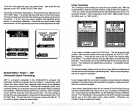
SELECT DIG.
SIZES
n-
s
a-
os
SONAR MENU
-
PAGE 4
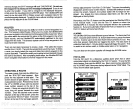
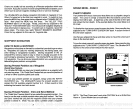
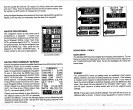
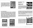
SELECT UNITS OF MEASURE
The UltraNavGPS can
display
the water
depth
in feet or
meters,
surface
water
temperature
in
degrees
Fahrenheit or
Celsius,
speed
in
statute
miles
per
hour or
knots,
and distance
(log)
in miles or nautical miles.
This
menu switches all
displays
to their metric
equivalent
and back
again.
You
cannot switch each
display individually.
To
change
the units of
measure,
first
press
the menu
key
four times. The
screen at the
top
of the next
page appears.
Next,
press
the
key adjacent
to the "SELECT UNITS OF MEASURE" label. The screen at the above
right appears.
Now
pressthe keyadjacenttothe
"CHANGETO
METERS,
O,
NAUTICAL MILES" label. The unit of measure
change
to the
metric
equivalent. Repeat
these
steps
to switch the units of measure
again.
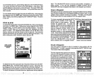
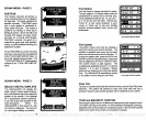
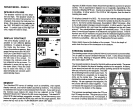
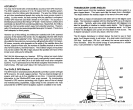
PLOTTER
The
plotter
lets
you
see
your
course and direction of travel on the screen.
If
you've
recalled a
waypoint,
the
plotter
shows
your
starting location,
present position,
and destination.
However,
you
do not have to recall a
waypoint
to use the
plotter.
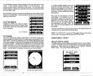
To use the
plotter, simply press
the
PLOT
key.
A screen similar to the one
below
appears. _____________________
The
flashing
cross is
your present position.
The solid line is
your
track,
or
path
you
have
just
traveled. The circle is a
compass
rose
marked with
North, South, East,
and West.
The circle's radius
displays
at the
top
of the
screen. This is the distance
from the centerto
the
edge
of the circle.
Your
present position
is shown at the bottom
of the screen.
If
your present position
starts to move outside
of the
circle,
the UItraNavGPS clears
the
display,
then re-draws
your present
position
closer to the center of the
screen. Your
present position
will
always
be
displayed
on the
plotter.
To clear the
plotter
screen,
see
the Plotter Menus section.
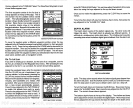
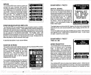
Plotting
with
a
Waypoint
Using
the
plotter
with a recalled
waypoint
or route is an
easy
wayto
see the
effects of wind and current on
your
boat. It also
simplifies navigation
to a
fixed
point.
To use the
plotter
in this
manner,
first recall a
waypoint
or start a route.
(Seethe
Waypoint
Recall section for more informa-
tion.)
Then
press
the PLOT
key.
A screen
similar to the one below
appears.
The "5" is
your starting
location.
This was
your position
when
you
recalled the
waypoint.
The
flashing
cross is
your present position,
and the "0" is the destination
(recalled way-
point).
If
you
are
using
a
route,
it's the first
waypoint
in the route. The dotted line is the
shortest,
most direct course from the
starting
point
to the destination. Follow this line to
get
to the
waypoint.
'4
-I
1w •1
E
SMALL DIGITAL DISPLAY
i'
E
24
49
PLOTTER SCREEN
PDF compression, OCR, web-optimization with CVISION's PdfCompressor