


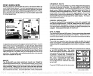
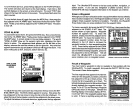
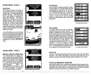
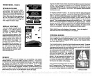

SONAR MENU
-
PAGE 2
FASTRAK
This feature converts all echoes to
short horizontal lines
on
the
display's
far
right
side.
The
graph
continues to
operate
normally.
FASTRAK
gives
you
a
rapid update
of conditions di-
rectly
under the boat. This makes it
useful for ice
fishing,
or when
you're
fishing
at anchor. Since the unit is not
moving,
fish
signals
are
long,
drawn
out lines on a normal chart
display.
FASTRAK converts the
graph
to a
vertical bar
graph
that,
with
practice,
makes a useful addition to
fishing
at a
stationary
location.
To turn FASTRAK
on, press
the menu
key twice,
then
press
the
key adjacent
tothe'TLJRN FASTRAKON" label. To
turn it
off, repeat
the same
steps.
The
'TURN FASTRAK OFF' label
appears
instead of the "TURN FASTRAK ON"
label.
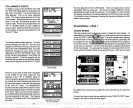
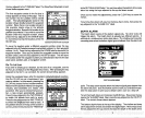
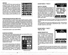
SONAR MENU-PAGE 3
SELECT DIGITAL DISPLAYS
The
UltraNavGPS
can
display
the
depth, speed,
surface
watertempera-
ture,
and distance
log
on the
upper
left
portion
of the
screen,
if the
optional
ST-T
speed/temp
sensor is attached.
It can also show
your position
in lati-
tude/longitude.
When the
UltraNavGPS is first turned
on,
only
the
depth
is
displayed.
You can turn
on each
digital display
as desired.
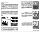
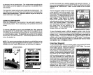
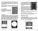
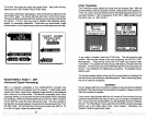
Plot Radius
Use this menu to
change
the
plotter's
radius.
The
plot
radius is .05 statute miles
when
the
UltraNavGPS is turned on for the
first time.
The available
plot
radii are
.05, .10, .25,
.50,1,
2, 5, 10, 20,50,
and 100 miles. This lets
you
"zoom in"
to
see small variations in
your
course or "zoom out" to
see
your starting
position, present position, track,
course,
and
destination.
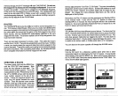
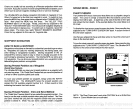
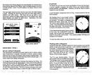
Plot
Update
The
plotter
shows
your
track
by drawing
a
solid line behind
your present position.
The
position
is
updated
once
every
two seconds
whenthe unit isturned on forthefirsttime.
To
change
the
update rate, press
the MENU
key
whiletheunit
isintheplottermode. Nowpress
the
key adjacent
tothe PLOT UPDATE label.
The screen shown at
right appears.
The
available
plot updatetimes
are
2,5, 10,
and 30
seconds.
1, 2, 5,
and 10 minutes.
Simply
press
the
key adjacent
to the desired
update
time. The UltraNavGPS
immediately
returns
to the
plotter
screen
using
the new time.
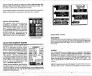
Clear Plot
r2
±oMI
:i1
EELa10°
PLOTTER RADIUS MENU
—
-
=-
33
EM:
s-
r
k
103
OM
—
..
CLEAR
-
I
CLEflR NOR:
a
________
I.-
PLOTTER UPDATE MENU
To clearor erasethe solidtrack line fromthe
screen,
usethe Clear Plot menu
selection.
The
plotter
will continue to draw
your
track after this
key
is
pressed,
however
your present position
will be centered on the screen.
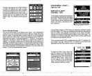
TRUE and MAGNETIC POSITION
Most
people
realize there is a difference between true and
magnetic
north.
True north is the
top
of the world. It's where all lines of
longitude converge.
Magnetic
north is the location our
compasses point.
It
lies
several
hundred
miles to the south of true
north,
at a location in Canada.
22
51
PDF compression, OCR, web-optimization with CVISION's PdfCompressor