


and
the outside line and the CDI
range
is 0.2
miles,
then
your
cross track
error
is 0.1 miles. The CDI
range
isthe
same as the CDI alarm
setting.
See
the section
on GPS alarms to
change
the
CDI
range.
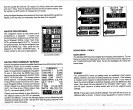
Using
the
digital displays
at the bottom
of the screen
along
with the
graphical
display
at the
top
lets
you accurately
steer the boat to a
waypoint.
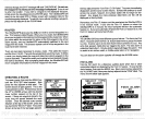
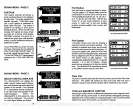
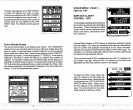
NAVIGATION
SCREEN
The
navigation
screen
is used when
you're
navigating
to a
waypoint.
It shows
your
present position,
distance
to
go (DTG),
Bear-
ing
to
Waypoint (BRG),
Cross Track Error
(XTE),
and
waterdepth (DEPTH).
Tousethe
navigation
screen,
first recall
a
waypoint,
then
press
the MENU
key.
Next, press
the
key
adjacent
to the "NAy. SCREEN
label. A
screen similar to the one
at
right appears.
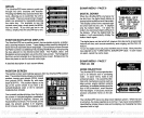
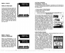
NAVIGATION SUMMARY SCREEN
IN
31°OtB'12
i s2ffO.ç3
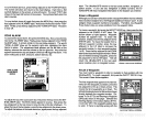
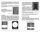
Another
navigation
screen
is availablethat shows
more information than
the
Navigation
screen,
but in smaller numbers. _______________________
This is the
Navigation Summary
screen.
Again,
it's used when
navigating
to
awaypoint.
To use
it,
first
press
the
MENU
key
twice.
Now
press
the
key adjacent
to the
NAV SUM-
MARY SCREEN label.
The screen shown
below
appears.
This
display
shows Distance
To Go
(DIG),
Cross Track
Error
(XTE),
Bear-
ing
to
Waypoint (BRG),
Course Over Ground
(COG),
Speed
Over Ground
(SOG),
Altitude
(ALT),
Fix,
time of
day (TIME),
today's
date
(DATE),
and water
depth (DEPTH).
Please
note that altitude is also affected
by
__________
the
ellipsoid
used
by
the GPS to calculate
position
and
altitude. Errors in the Altitude
display
can be affected
by
both
ellipsoid
and
high
levels of SA. See the PCF and
Accuracy
sections
in this
manual for more
information.
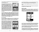
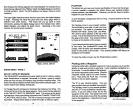
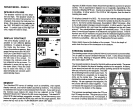
SONAR MENU
-
PAGE
4
UNITS
or
MEASURE
ARE IN
BACKLIGHTS
The UltraNavGPS
has internal
lightsforthe display
and
keyboard.
To turn
these
on,
press
the menu
key
four
times,
then
press
the
key
adjacent
to
the "TURN BACKLIGHT
ON" label. To turn the
backlights
off, repeat
the
same
steps.
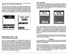
PRESET
The UItraNavGPS
saves all
settings
such
as
sensitivity,
chart
speed,
display
contrast,
and more in
battery
backed-up memory.
This
memory
is retained even if
power
is disconnected
from the unit. If
you
need to
return the sonar
settings
to the
factory
defaults, press
the MENU
key
four
times. Now
press
the
key adjacent
to the "PRESET
UNIT" label.
The
unit will
reset,
return
to a sonar screen with all
of the
original
factory
settings.
NOTE: Preset also resets
all GPS
settings!
The GPS
will have to be re-
initialized after a
preset.
It
doesn't erase
waypoints
or routes,
however.
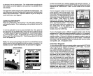
d
— a.uu
Ji —
'
4
-A
FEET
MILES
l_:HRNI.jE
Tu
I1ETEF.:S
NALIT. F'l I
LEE;
MORE
RO.22
NAVIGATION SCREEN
SUMMARY
IJTG(MI) 2.89
XTE(MI) 0.06
MAG BRIB 039°
MAO COG
045°
SOG(MPH)
18.49
ALT (FT) 10
FIX
TIME
9:49:23
DATE 08/08/91
9
DEPTH
(FT)
48
25
PDF compression, OCR, web-optimization with CVISION's PdfCompressor