


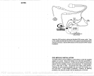
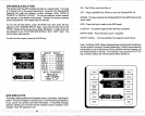
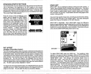
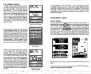

CHANGING STARTUP SETFINGS
The UItraNavGPS must be initialized when it's turned
on for the first time.
This is described at the
beginning
of the GPS section in this manual.
However,
if
you
wish to
change only
one of the
parameters (such
as
time),
use the menu features in the "CHANGE SETUP"
menu. To do
this,
press
the MENU
key,
then
press
the
key adjacent
tothe "CHANGE SETU P" label.
The screen shown
below
appears.
______________________
Using
the menus on this and
following
menu
pages, you
can
change
the Initial
Position,
Time-Date-Time
Offset,
or Altitude without
_____________________
affecting any
other initialization
setting.
All of ____________________
these
menus work
identically
to the ones
described in the initialization section at the
beginning
of the GPS section.
Afteryou
make ____________________
achange,
the unit
returnstotheGPSorplotter
screen,
however. It doesn't
automatically
sequence
through
the initialization
menus.
________ ________
For
example,
if
you
move a
long
distance
(over
100
miles)
with the unit
off,
you may
want to enter a new initial
position
to
help
the
UltraNavGPS find the correct
position quicker.
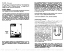
PCF OFFSET
(Position
Correction
Factor)
The GPS
navigation system
relies
on
complex
mathematical calculations to
determine
yourposition
based on satellite data and otherfactors. One factor
is the Earth's
shape.
Since the Earth is not a true
sphere,
variations in the
calculations
have to be made to accommodate deviations. To make matters
more
complex,
not
everyone
uses the same data to determine what the
deviations are.
The size and
shape
of the
ellipsoids
that are used to
approximate
the earth's surface are
improved
often. This can lead to errors
if
your navigation
device uses
one
ellipsoid,
while
your
chart uses a different
one. The term used for these
ellipsoids
is
"datum."
To reduce the error factor between
datum,
the UltraNavGPS
gives you
the
capability
to move or "offset" the
position
shown on the
displayto
match one
shown on the chart. The unit adds this offset to all
position displays.
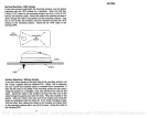
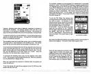
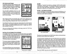
GRAYLINE®
GRAYLINE lets
you distinguish
between
strong
and weak echoes. It
"paints" gray
on
targets
that are
strongerthan
a
preset
value. This allows
you
to tell the difference between a hard and soft bottom.
For
example,
a
soft,
muddy
or
weedy
bottom returns
a weaker
signal
which is shown
with a narrow or no
gray
line. A hard bottom
returns a
strong signal
which
causes a wide
gray
line.
If
you
have two
signals
of
equal
size,
one with
gray
and the other
without,
then the
target
with
gray
is the
stronger signal.
This
helps
distinguish
weeds from trees on the
bottom,
or fish from structure.
GRAYLINE® is
adjustable.
Since GRAYLINE®
shows the difference
between
strong
and weak
signals,
adjusting
the
sensitivity may require
a
different GRAYLINE®
level,
also. The level chosen
by
the UltraNavGPS
at
poweron
is
usually adequate
for most conditions.
Experiment
with
your
unit to find the
GRAYLINE®setting
that's
best for
you.
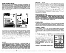
_____
---20
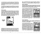
To
adjust
GRAYLINE
press
the SENS
key.
The
sensitivity
menu
appears
in the
upper
left side of the
display,
while
the GRAYLlNEwitch
label
appears immediately
beneath it. First
press
the
key adjacent
to the
"SENS GRAY" label. This
changes
the
sensitivity adjust
menu to
GRAYLINE®
adjust.
Now
press
the
key adjacent
to the
up
arrow
to
increase the
gray
level. Press the
key adjacent
to the down arrow to
decrease it. The
percentage
of GRAYLIN
E® in
use
changes
as the arrow
keys
are
pressed.
The bar chart also
gives
a
graphical
indication of the
GRAYLINE® level. You can see
the
change
on the screen
(both
on the
menu and on the chart
record)
as
you
press
the
keys.
After
you've
made
the
adjustmentr press
the CLEAR
key
to erase the
menu.
A
ENTER
INITIAL
POS IT ION
ENTER
TI P1 E/
DATE
N OR
}9•3
FT
•4
jj
01
cRAvuNea—
62
11
PDF compression, OCR, web-optimization with CVISION's PdfCompressor