


GPS TABLE OF CONTENTS
GPS -HOW
IT WORKS 41
ACCURACY
42
THE EAGLE GPS MODULE
42
GETTING STARTED
43
INITIALIZATION
43
INITIAL POSITION
43
ALTITUDE
44
TIME/DATE
44
MENUS
46
POSITION/NAVIGATION DISPLAYS 46
POSITION DISPLAY
46
STEERING SCREEN
47
NAVIGATION
SCREEN 48
NAVIGATION
SUMMARY SCREEN 48
PLOTTER 49
USING THE PLOTTER WITH A WAYPOINT
49
PLOTTERMENUS
50
PLOT DISPLAY
50
PLOTtER RADIUS
51
UPDATE INTERVAL
51
CLEAR PLOT
51
TRUE AND MAGNETIC POSITION
51
HOW TO
SAVE A WAYPOINT 52
SAVING
CURRENT POSITION
52
WAYPOINT QUICKSAVE
52
VIEW AND SAVE WAYPOINT
52
ENTER NEW WAYPOINT
53
GO TO LAT/LON 54
ERASE A WAYPOINT
55
WAYPOINT RECALL
55
ROUTES
56
CREATING A ROUTE 56
FOLLOWING A ROUTE 58
CANCELLING A ROUTE
59
ERASING A ROUTE
59
GPSALARMS
59
ARRIVAL ALARM
59
CDI ALARM AND
RANGE
60
SATELLITE INFORMATION SCREEN 60
ENGINEERING SCREEN
61
TURN NAVIGATION OFF
(CANCEL NAV)
62
CHANGING STARTUP SETTINGS
62
PCF
OFFSET 62
NMEA COMMUNICATION
64
PRESET 64
MAN OVERBOARD
65
GPS MODULE SELF TEST
66
GPS SIMULATOR
66
SPECIFICATIONS
67
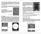
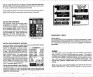
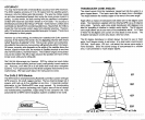
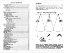
FISH
ARCHES
Fish arches are created when the cone of sound
passes
over a fish.
The distance to a fish when the cone first strikes
it is shown as
"A"
below. When the center of the
cone strikes the
fish,
the distance is
shorter as shown "B". As the
cone leaves the
fish,
the distance
increases
again
as
shown in "C".
BOAT'S
DIRECTION OF TRAVEL
A B
I
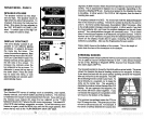
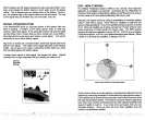
When the
Fish I.D. mode is
off,
the
depth
of the
water will affect the
size and
shape
of the fish arch due to the cone
angle
diameter.
For
example,
if the cone
passes
over a fish in shallow
water,
the
signal
displayed
on the
UltraNavGPS
may
not arch at all. This
is due to the
narrow cone diameter and the resolution limitations of the
display.
C
40
33
PDF compression, OCR, web-optimization with CVISION's PdfCompressor