


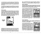
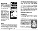
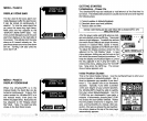

SONAR MENU
-
PAGE 5
SPEAKER VOLUME
______________
The
speaker
volume has two
steps
-
low
and
high.
The
speaker
volume is
high
when
the unit is first turned on. To
change it,
first
press
the menu
key
five
times. Now
press
the
key adjacent
to
the 'SET
SPEAKER VOLUME LOW"
label.
To switch back to the
high
vol
___________
ume,
repeat
the
above
steps.
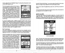
DISPLAY
CONTRAST
The unit's
display
contrast is ad
_________
justable
to suit
different
lighting
conditions. To
adjust
it,
first
press
the
menu
key
five times. The
menu
shown above
appears.
Now
press
the
key
next to the "ADJUST
DISPLAY
CONTRAST' label. The
display
contrast arrows
appear
on
the left side of
the screen. To
increase the
contrast,
press
the
key adjacent
to the
up
arrow. To
decrease
it, press
the
key
next to
the down arrow.
Press the Clear
key
to erase
the
menu,
or wait
approximately
ten seconds and it
automatically
clears.
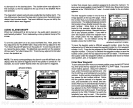
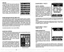
MEMORY
The UltraNavGPS
saves all
settings
such as
sensitivity,
chart
speed,
display contrast,
and
more
in
battery backed-up memory.
This
memory
is retained
even
if
power
is disconnected from the
unit.
If
you
wish to turn
the
memory
save feature
off,
press
the
key adjacent
to
the "TURN
M EMORYSAVE
OFF" label on the fifth sonar menu
page.
This does NOT
affect GPS initial
settings, waypoints,
or routes. Toturn
the
memory
save
feature on
again,
press
the MENU
key
until the fifth
page
appears,
then
press
the
key
next to the "TURN MEMORY SAVE ON"
label.
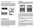
degrees,
50.853 minutes. Below
the
present position
is course over
ground
(COG).
This is
expressed
in
degrees
true or
magnetic, depending
on the
mode the UltraNavGPS is in. Course over
ground
is the direction the boat
is
travelling.
In other
words,
if the
COG is 180
degrees,
then the boat is
heading
due south.
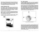
Fix
displays
beneath the SaG. Fix
shows how well the
latitude/longitude
filter in
the receiver is
working.
The best
fix
number is nine
(9),
the worst is
one
(1).
As the fix number
decreases,
the
position's "jitter"
increases. Jitter
is the small
position changes
around a
location. In other
words,
if
you
hold
the
boat
perfectly
still,
you'll
see the
position
displayed
on the unit
"jump
around."
Very
small
position changes
will
constantly
occur, This is called
jitter;
it's normal and
happens
in all electronic
navigation
devices.
If
the fix
number and HDOP
numbers are
good,
then the
latitude/longitude position
shown on the
display
should also be
good, excluding
the effect of S/A
(selective availability).
Also see
the
Engineering
Screen section.
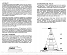
Water
depth
shows at the bottom of the screen. This is the
depth
of
water from the face of the
transducer to the bottom.
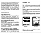
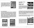
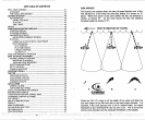
STEERING SCREEN
The
steering
screen shows a
pictorial
viewof
your
boat and coursetravelled.
This is called a
Course Deviation Indicator or CDI. It also
shows Distance
To Go
(DTG), Bearing
to
Waypoint (BRG),
Course Over Ground
(COG),
and water
depth (DEPTH).
Your
present position
is shown
by
the circle
with an arrow inside. The arrow
shows the direction the boat is
heading
relative to the
waypoint.
In
theory,
if
you
steer the boat with the arrow
always
pointing
towards the
waypoint,
then
you
will arrive at the
waypoint.
The solid
line
extending
from the circle is
yourtrack.
To
travel
directly
to a
waypoint, try
to
keep
the
circle on the center line.
The
waypoint
is
depicted by
anothercircle at
thetopofthe
CDI
display.
As
you approach
the
waypoint,
the
two circles will move
closer
together.
If
you
travel
past
the
waypoint,
the
waypoint's
circle
will move to the bottom of the
display.
The numbers
immediately
below the CDI are
the CDI
range
in miles. This
gives you
an idea
of how faroff course
you
are. For
example,
if
the circle is
halfway
between the course line
SPEnKER
L'iJLLIF'lE
L 0 Li
a
TURN
MEMORY
Fl ORE
1
FT
-20
-C
26
47
STEERING SCREEN
PDF compression, OCR, web-optimization with CVISION's PdfCompressor