


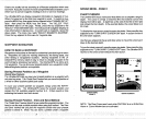
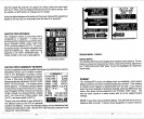
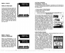
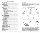


Both 8
degree
and 20
degree
transducers
give
accurate
bottom read-
ings,
even
though
the bottom
signal
is much wider on the 20
degree
model. This
is because
you
are
seeing
more of the bottom. Remem-
ber,
the
shallow
edge
of the
signal
shows
you
the true
depth.
The rest
of the
signal
tells
you
whether
you
are over
rocks, mud,
etc.
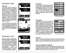
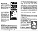
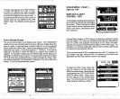
SIGNAL INTERPRETATION
Your UtraNavGPS
gives
an accurate
picture
of the bottom that
your
boat is
passing.
A bottom of firm
sand,
gravel,
shell,
or hard
clay
returns a
fairly
wide
signal.
If the automatic mode is off and the
signal
narrows
down,
then it means that
you
have moved over a mud bottom.
Mud absorbs the sound wave and returns a weak
signal.
Turn
up
the
sensitivity
to see a better bottom
signal.
Big
rocks or
stumps
on a smooth bottom send back
signals
above the
bottom level
signal.
The
height
of the
signal depends
on the
target's
height.
As
you pass
over a
post,
it should be
clearly
visible as a short
line
extending
above the bottom
signal.
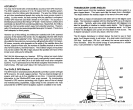
A
steep slope
returns a wide
signal,
the
steeper
the wider.
Signals
returned from a
high
underwater cliff are
usually
the widest of all.
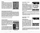
DIGITAL
BOTFOM
DEPTH\\
GPS
-
HOW
IT
WORKS
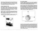
The Global
Positioning System (GPS)
is the
newest,
most
high-tech
approach
to
navigation yet
devised. Conceived
by
the
Department
of
Defense
(DOD)
andthe United States
military,the
GPS
system
is an answer
to their needs of 24 hour
global positioning,
365
days
a
year.
Basically,
the
system
works
by using
a constellation of
satellites
orbiting
Earth
11,000
miles in
space.
There
will
be
21 satellites in orbit when the
system
is
fullyoperational.
Three more satelliteswill act as
spares,
foratotal
of 24. When all satellites are in
place,
at least four of them
will be in view
nearly anywhere
on Earth
twenty
four hours a
day.
The GPS receiver
requires
at least three satellites to
give
a "2D" fix.
(A
2D fix is
your position
in
latitude/longitude.
A 3D
fix
is
your latitude/longitude plus altitude.)
When
it locks on to at least
four
satellites,
it
displays
a 3D fix.
It ta}cos three satellites to determine
position.
As the receiver locks on to each
satellite,
it calculates the distance from the
satellite
by measuring
the
length
of time it takes the radio
signal
to reach it.
Each satellite has an
extremely
accurate clock which tells the receiverwhen
the radio transmission started. The receiver
compares
that time
against
its
own
clock,
thus it knows how
long
it took the radio
signal (travelling
at the
speed
of
light!)
to reach it. If
you
know time and
speed,
then
you
can
calculate distance. Once
you
have this from three
satellites,
then the
receiver can determine
position.
32
41
mi-ITO
r
38.3
FT
-C
----10
-C
-C
-C-c
PDF compression, OCR, web-optimization with CVISION's PdfCompressor