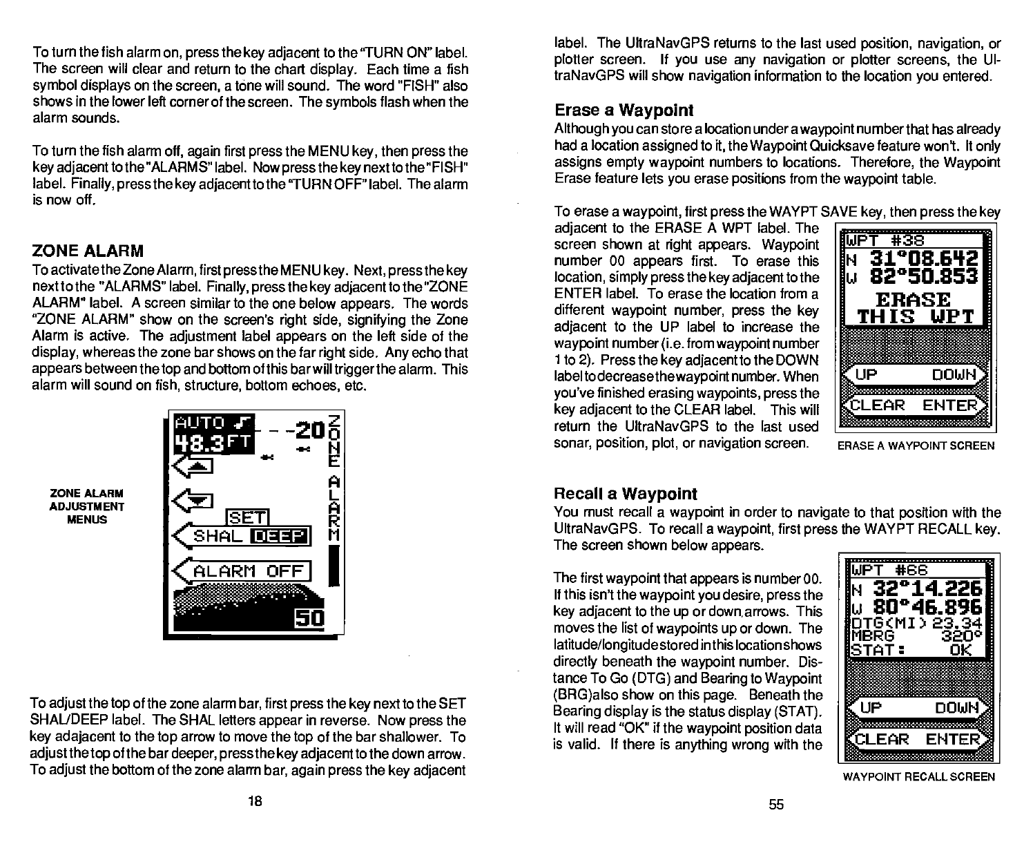
The first
waypoirit
that
appears
is number 00.
If
this isn't the
waypoint you
desire,
press
the
key adjacent
to the
up
or down arrows. This
moves the list of
waypoints up
or down. The
latitude/longitude
stored in this location shows
directly
beneath the
waypoint
number. Dis-
tance To Go
(DTG)
and
Bearing
to
Waypoint
(BRG)also
show on this
page.
Beneath the
Bearing display
is the status
display
(STAT).
It will read "OK" if the
waypoint position
data
is valid. If there is
anything wrong
with the
18
55
To turn the fish alarm
on,
press
the
key adjacent
to the 'TURN ON" label.
The screen will clear
and return to the chart
display.
Each time a fish
symbol displays
on
the
screen,
a tone
will
sound. The word "FISH" also
shows in the lower left corner of the screen. The
symbols
flash when the
alarm sounds.
To turn the fish alarm
off,
again
first
press
the MEN U
key,
then
press
the
key adjacenttothe
"ALARMS" label. Now
press
the
key
nexttothe "FISH"
label.
Finally, press
the
key adjacent
tothe 'TURN OFF" label. The alarm
is now oft.
ZONE ALARM
To activatethe Zone
Alarm,
first
pressthe
MENU
key.
Next,
press
the
key
next to the "ALARMS" label.
Finally, press
the
key adjacenttothe
"ZONE
ALARM"
label.
A
screen similar to the one below
appears.
The words
"ZONE ALARM" show on the screen's
right
side,
signifying
the Zone
Alarm is active. The
adjustment
label
appears
on the left side of the
display,
whereas the zone bar
shows on the far
right
side.
Any
echo that
appears
between
the
top
and bottom of this bar will
triggerthe
alarm. This
alarm will sound on
fish, structure,
bottom
echoes,
etc.
label.
The UltraNavGPS returns to the last used
position, navigation,
or
plotter
screen. If
you
use
any navigation
or
plotter
screens,
the UI-
traNavGPS will show
navigation
information to the location
you
entered.
Erase a
Waypoint
Although you
can store a location under a
waypoint
numberthat has
already
had a location
assigned
to
it,
the
Waypoint
Quicksave feature woni. It
only
assigns
empty waypoint
numbers to locations.
Therefore,
the
Waypoint
Erase
feature lets
you
erase
positions
from the
waypoint
table.
AUTO
I}93FT
To
erase a
waypoint,
first
press
the WAYPT SAVE
key,
then
press
the
key
adjacent
to the ERASE A WPT
label. The __________________
screen shown
at
right appears. Waypoint
WPT *38
number 00
appears
first. To erase this
N 31°08.61'2
location,
simply pressthe key adjacenttothe
U 82°50.853
ENTER label. To erase the location from a
ERASE
diflerent
waypoint
number,
press
the
key
TH is UPT
adjacent
to the UP label to increase the
_______
________
waypoint
number
(i.e.
from
waypoint
number
______
ito
2).
Press the
key adjacent
to the DOWN
_______ ________
labeltodecreasethewaypoint
number. When
you've
finished
erasing waypoints, press
the
key adjacent
to the CLEAR label. This will
__________________
return the UItraNavGPS to the last used
______________________
sonar,
position, plot,
or
navigation
screen.
ERASE A WAYPOINT SCREEN
ZONE ALARM
ADJIJSTM ENT
MENUS
.I'nz
-
-
—N
—
E
A
L
A
R
OFFI
—
ISETI
çSHAL
EaaI
flRER
<ALARM
Recall a
Waypoint
You must recall a
waypoint
in order to
navigate
to that
position
with the
UItraNavGPS. To recall a
waypoint,
first
press
the WAYPT RECALL
key.
The screen shown below
appears. _____________________
WPT *66
To
adjust
the
top
of
the zone alarm
bar,
first
press
the
key
next to the SET
SHALJDEEP label. The SHAL
letters
appear
in
reverse. Now
press
the
key adajacent
to the
top
arrow to move the
top
of the bar shallower. To
adjustthetop
of
the bar
deeper,
press
the
key adjacent
to the down arrow.
To
adjust
the bottom of
the zone alarm
bar,
again press
the
key adjacent
N 32°14.226
u 80046996
DTG(MI) 23.34
MBRG 3200
STAT: OK
l.a
nR::
L4
WAYPOINT RECALL SCREEN
PDF compression, OCR, web-optimization with CVISION's PdfCompressor


