


3. PLOTTER OPERATION
3-28
3.8 Waypoints
In navigation terminology, a waypoint is a particular location on a voyage
whether it be a starting, intermediate or destination point. A waypoint is the
simplest piece of information your equipment requires to get you to a destination,
in the shortest distance possible.
This unit has 999 waypoints into which you can enter position information. You
may enter a waypoint five ways: at own ship position, at MOB position (see page
1-14 for details), by cursor, by range and bearing, and through the waypoint list
(manual input of latitude and longitude).
3.8.1 Entering waypoints
Entering a waypoint at own ship position
Press the [SAVE/MOB] key momentarily to store your position as a waypoint.
This new waypoint is saved to the waypoint list, under the youngest empty
waypoint number.
Entering a waypoint with the cursor
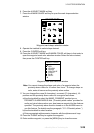
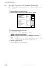
1. Press the [MENU] key to open the menu.
2. Press the C:WAYPOINTS/ROUTES, A:WAYPOINTS and C:WAYPOINT BY
CURSOR soft keys. The plotter display appears.
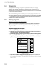
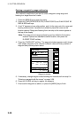
3. Operate the trackball to place the cursor where you want to enter a waypoint.
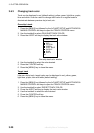
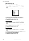
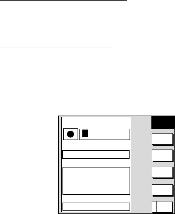
4. Press the D:NEW WPT soft key. The waypoint window appears and it shows
waypoint mark shape, waypoint name, comment (default: time and date),
position of waypoint and proximity alarm radius.
NEW
WPT
▲
34°44.000'N
135°21.000'W
359.9°
0.00nm
002WPT
00:00 01JAN00
34°44.000'N
135°21.000'W
359.9°
0.00nm
003WPT
00:00 01JAN00
34°44.000'N
135°21.000'W
359.9°
0.00nm
COMMENT
02:36 01JAN01
LAT
34° 12. 134'N
LON
134° 12. 345'W
PROXIMITY ALARM RADIUS
0. 00nm
MARK
0 01WPT
NAME
SELECT
MARK
A
RETURNE
COORD
TYPE
B
N< - - >S
E< - - >W
C
SAVED
Waypoint window
5. If you do not need to change the waypoint data, press the D:SAVE soft
key to register the waypoint. The steps which follow show you how to change
waypoint data.
offered by Busse-Yachtshop.de