


SP - 5
SPECIFICATIONS OF VIDEO PLOTTER GD-1900C-BB
1 PLOTTER FUNCTION
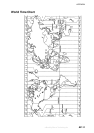
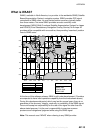
1.1 Projection Mercator
1.2 Usable Area 85 latitude or below
1.3 Position Indication Latitude/longitude, Loran C LOP or DECCA LOP
1.4 Effective Projection Area 0.125 nm to 1,024 nm (at equatorial area)
1.5 Track Display Plot interval: by time (1 sec. to 99 min. 59 sec.) or
by distance (0 to 99.9 nm)
1.6 Colors Red, yellow, green purple, light-blue, blue, white
1.7 Memory Capacity Track/mark: 8000 points, Waypoint: 999 points,
Route: 200 routes with 35 waypoints each
1.8 MOB 1 point
1.9 Electronic Chart FURUNO chart card or NAVIONICS chart card available
C-MAP chart card also available for C-MAP NT Model
1.10 Alarms Arrival and Anchor watch, Cross track error and proximity
alarms, Ship’s speed in and out alarms, Water temperature,
Trip alarm, Fish alarm, Bottom alarm (ETR required)
2 INTERFACE
2.1 Input Data IEC 61162-1 (NMEA 0183 Ver1.5/2.0)
Own ship’s position: GGA>RMC>RMA>GLL
Ship’s speed: RMC>RMA>VTG>VHW
Bearing (True): HDT>HDG
*1
>HDM
*1
>VHW
Bearing (Magnetic): HDM>HDG
*1
>HDT
*1
>VHW
Course: RMC>RMA>VTG
Water depth: DPT>DBT>DBS>DBK
Wind: MWV>VWT>VWR
Water Temperature: MTW
Time: ZDA
*1
: calculated by magnetic deviation
2.2 Output Data
Alarm signal 12 VDC, 100 mA or less
NMEA 0183 Ver1.5 GGA, GLL, RMA, RMC, GTD, VTG, ZDA (GPS data required)
RMB, WPL, BWC or BWR, APB, AAM, BOD, XTE, VHW, MTW,
DPT or DBT, DBS (ETR required), TTM (ARPA required)
3 POWER SUPPLY
3.1 Rated Voltage/Current 12-24 VDC: 1.5-0.8 A
offered by Busse-Yachtshop.de