


D Logs Summary
MiLLennium GPSCard SW Version 4.503/4.52 Command Descriptions Manual Rev 2 163
GPGLL Geographic Position
Latitude and longitude of present vessel position, time of position fix, and status. This log will output all null data
fields until the GPSCard has set fine time as monitored by the receiver status word, see Table D-5 Receiver Self-
Test Status Codes on Page 198, bits 8,9 and 10.)
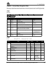
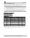
Structure:
Example:
$GPGLL,5106.7198674,N,11402.3587526,W,220152.50,A*1B[CR][LF]
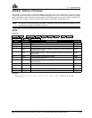
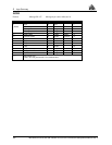
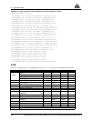
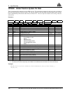
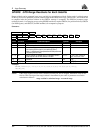
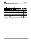
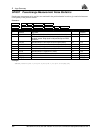
$GPGLL lat lat dir lon lon dir utc data status *xx [CR][LF]
Field Structure Field Description Symbol Example
1 $GPGLL Log header $GPGLL
2 lat Latitude (DDmm.mm) llll.ll 5106.7198674
3 lat dir Latitude direction (N = North, S = South) a N
4 lon Longitude (DDDmm.mm) yyyyy.yy 11402.3587526
5 lon dir Longitude direction (E = East, W = West) a W
6 utc UTC time of position (hours/minutes/seconds/decimal
seconds)
hhmmss.ss 220152.50
7 data status Data status: A = Data valid, V = Data invalid A A
8 *xx Checksum *hh *1B
9 [CR][LF] Sentence terminator [CR][LF]