


C Commands Summary
MiLLennium GPSCard SW Version 4.503/4.52 Command Descriptions Manual Rev 2 99
FIX HEIGHT
This command configures the GPSCard in 2D mode with its height constrained to a given value. The command
would be used mainly in marine applications
where height in relation to mean sea level may be considered to be
approximately constant. The height entered using this command is always referenced to the geoid (mean sea level,
see the PRTKA/B log in Chapter 4 and Appendix D) and uses units of meters. The FIX HEIGHT command will
override any previous
FIX HEIGHT or FIX POSITION command and disables the output of differential corrections.
The receiver is capable of receiving and applying differential corrections from a reference station while FIX
HEIGHT is in effect. Use the UNFIX command to disable the current FIX command. No special solution status is
reported in the POSA/B or PRTKA/B logs for a 2 dimensional solution. This mode is detected by the standard
deviation of the height being 0.001m.
Syntax:
Example:
fix height 4.567
or
fix height auto
REMEMBER: Any error in the height estimate will cause an error in the position computed of the same order
of magnitude or higher. For example, if the user fixed height to zero and the antenna was installed
on a 20 meter mast, the position can be expected to be in error by 10 to 60 meters, depending on
the geometry of the satellites. This command should only be used when absolutely necessary, i.e.,
when only three satellites are visible.
NOTE: This command only affects pseudorange corrections and solutions, and so has no meaning within the
context of RT-2 and RT-20.
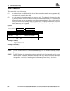
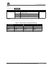
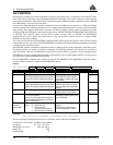
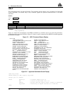
FIX HEIGHT value
Syntax Range Value Description Default
FIX HEIGHT - Command unfix
value height -1,000.0 to 20,000,000.0
Height in metres above mean sea level
auto The receiver will automatically fix the height at the last calculated value if the
number of satellites available is insufficient for a 3-D solution, to provide a 2-D
solution. Height calculation will resume when the number of satellites available
returns to 4 or more. The use of the UNFIX command, or a different FIX
command will disable the automatic fix height mode. It is disabled by default.