


D Logs Summary
168 MiLLennium GPSCard SW Version 4.503/4.52 Command Descriptions Manual Rev 2
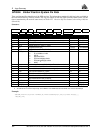
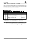
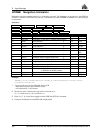
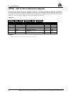
GPRMB Navigation Information
Navigation data from present position to a destination waypoint. The destination is set active by the GPSCard
SETNAV command. If SETNAV has been set, a command to log either GPRMB or GPRMC will cause both logs
to output data.
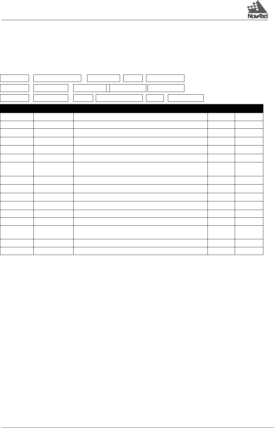
Structure:
Example:
$GPRMB,V,0.011,L,START,END,5106.7074000,N,11402.3490000,W,0.0127611,153093,
0.3591502,V*13[CR][LF]
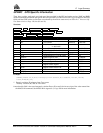
1 - If cross track error exceeds 9.99 NM, display 9.99
- Represents track error from intended course
- one nautical mile = 1,852 meters
2 Direction to steer is based on the sign of the crosstrack error,
i.e., L = xtrack error (+); R = xtrack error (–)
3 Fields 5, 6, 7, 8, 9, and 10 are tagged from the GPSCard SETNAV command.
4 If range to destination exceeds 999.9 NM, display 999.9
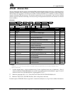
$GPRMB data status xtrack dir origin ID
dest ID dest lat
lat dir dest lon
lon dir
range
bearing
vel arr status *xx [CR][LF]
Field Structure Field Description Symbol Example
1 $GPRMB Log header $GPRMB
2 data status Data status: A = data valid; V = navigation receiver warning A V
3 xtrack
Cross track error 1
x.x 0.011
4 dir
Direction to steer to get back on track (L/R) 2
a L
5 origin ID
Origin waypoint ID 3
c--c START
6 dest ID
Destination waypoint ID 3
c--c END
7 dest lat
Destination waypoint latitude (DDmm.mm 3
llll.ll 5106.7074
000
8 lat dir
Latitude direction (N = North, S = South) 3
a N
9 dest lon
Destination waypoint longitude (DDDmm.mm) 3
yyyyy.yy 11402.349
10 lon dir
Longitude direction (E = East, W = West) 3
a E
11 range
Range to destination, nautical miles 4
x.x 0.0127611
12 bearing Bearing to destination, degrees True x.x 153.093
13 vel Destination closing velocity, knots x.x 0.3591502
14 arr status Arrival status: A = perpendicular passed
V = destination not reached or passed
A V
15 *xx Checksum *hh *13
16 [CR][LF] Sentence terminator [CR][LF]