


C Commands Summary
MiLLennium GPSCard SW Version 4.503/4.52 Command Descriptions Manual Rev 2 95
ECUTOFF
This command sets the elevation cut-off angle for usable satellites. The GPSCard will not start tracking a satellite
until it rises above the cutoff angle. If there are six or less satellites being tracked and one drops below this angle,
it will continue to be tracked until the signal is lost. However, if there are more than six satellites being tracked,
any that are below the cutoff angle will be dropped completely.
In either case, satellites below the ECUTOFF angle will be eliminated from the internal position and clock offset
solution computations only.
This command permits a negative cut-off angle; it could be used in these situations:
• the antenna is at a high altitude, and thus can look below the local horizon
• satellites are visible below the horizon due to atmospheric refraction
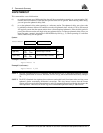
Syntax:
Example:
ecutoff 5
NOTE 1: When ECUTOFF is set to zero (0), the receiver will track all SVs in view including some within a few
degrees below the horizon.
NOTE 2: Care must be taken when using ECUTOFF because the information you are tracking from lower
elevation satellite signals are going through more atmosphere, for example ionospheric and
tropospheric, and therefore being degraded.
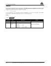
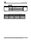
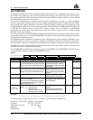
ECUTOFF angle
Syntax Range Value Description Default
ECUTOFF - Command
angle -90° to +90° Value in degrees (relative to the horizon). 0