


Chapter 1: Overview 1-1
Chapter 1: Overview
1.1 Introduction
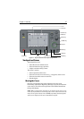
This handbook describes the Raynav 300 GPS Plotter.
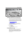
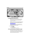
Note: Many illustrations in this handbook show example screens. The
screen you see on your display depends on your system configuration and
set up options, so it may differ from the illustration.
How this Handbook is Organized
Chapter 1 - Overview (this chapter) provides an overview of the
features and functions of the Raynav 300 GPS Plotter. You should read
this chapter to familiarize yourself with the GPS Plotter.
Chapter 2 - Getting Started provides an overview of the controls. It also
explains how to start using the GPS Plotter.
Chapters 3 - Operation provides detailed operating information for the
main plotter functions - plotting waypoints and routes, following routes,
using tracks, SmartRoute, Man Overboard and Data Log Mode.
Chapter 4 - Setting Up the GPS Plotter provides instructions for
setting up your GPS Plotter system to suit your preferences. You should
read this chapter to determine how to set up your system preferences.
Chapter 5 - Installation provides planning considerations and detailed
instructions for installing the GPS Plotter.
Chapter 6 - Maintenance & Fault Finding provides information on
user maintenance and what to do if you experience problems.
Appendix A lists the technical specifications for the GPS Plotter.
Appendix B defines the SeaTalk and NMEA data that is transferred on
integrated systems.
Appendix C provides a list of abbreviations used in this handbook.
An Index provides an easy lookup to specific keywords or topics.
Installation Templates are included at the end of this handbook.
A summary of the GPS Plotter controls and functions are provided on the
Quick Reference Card supplied with your system.