


Chapter 2: Getting Started 2-7
➤ To release the cursor from homed mode, use the trackpad to move the
cursor away from the vessel’s current position. The status bar shows the
current cursor position, bearing and range. The cursor no longer moves
with the vessel and no redraw occurs if the vessel moves off screen.
Changing the Display Center
You can move the area of the display center using the context-sensitive
cursor. This allows you to center your vessel in the center of the screen, or
to move the display so that your vessel is displayed off-center anywhere
on the screen.
➤ To move your vessel’s position off-center:
1. Move the cursor over your vessel’s position until the letters POS are
displayed.
2. Press ENTER to take control of the vessel’s position. The letters POS
are now in inverse video and the cursor symbol has changed to a
four-way arrow. This indicates that the cursor can be used to move the
display in any direction.
3. Use the trackpad to move the cursor to the required position.
4. Press ENTER to select the position and return to normal cursor con-
trol. The display is redrawn with the vessel’s position at the cursor.
Alternatively, you can press CLEAR to abandon the move and leave
the display (and vessel) in its former position.
➤ To center the display:
1. Use the trackpad to move the cursor to the vessel’s position. The cur-
sor text POS is displayed.
2. Press CLEAR. The display pans to show your vessel’s position is in
the center of the screen.
Changing the Display Scale
The RANGE key allows you to change the display scale so that you can
see a smaller or larger area on the screen.
You can change the display scale:
• To see either a larger scale (of a smaller area) or a larger area (at a
smaller scale) on the screen.
• To move the display to another area, by zooming out to a smaller
scale, then zooming in on another position centered on the cursor.
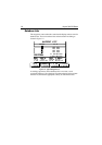
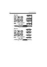
Each time you press the RANGE key, the display scale changes to the next
available setting. The status bar, shown in Figure 2-6, indicates the
distance from top to bottom of the screen, in nautical miles.