


Chapter 2: Getting Started 2-1
Chapter 2: Getting Started
2.1 Introduction
This chapter provides information, instructions and a simple
familiarization exercise in using the display. Operating information is
detailed in Chapter 3.
Conventions Used
Throughout this handbook, the dedicated (labelled) keys are shown in
bold capitals; for example, ENTER. The soft key functions, menu names
and options are shown in normal capitals; for example, SCREEN.
Operating procedures, which may consist of a single key-press or a
sequence of numbered steps, are indicated by a ➤ symbol in the margin.
Simulator
The plotter display unit includes a Simulator mode, which allows you to
practice operating your plotter without data from a GPS antenna. You
will need to use the set up options to switch the display unit to Simulator
mode, see Section 2.2, Power On/Off. You can use it in either of two
ways:
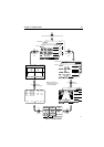
• Before the plotter has been installed on your vessel. In this case, you
only need to connect the plotter display unit to a 12V DC power sup-
ply, fused at 1A, connecting the red core from the power lead to posi-
tive (+) and the black core to negative (-); see Cable Running on page
5-11 for full details.
• After the plotter has been installed on your vessel, but while in the
marina or at anchor.
2.2 Power On/Off
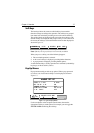
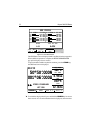
➤ To turn the display unit on, press the POWER key.
The keys light up and the introductory logo is displayed.
The GPS Status screen is displayed as shown in Figure 2-1.