


Prelim Pages iii
Raynav 300 GPS Plotter Owner’s Handbook
SAFETY NOTICES
WARNING: NAVIGATION AID
This device is intended to be used as an aid to navigation. Its
accuracy can be affected by many factors, including equipment
failure or defects, environmental conditions and incorrect
handling or use. It is the user’s responsibility to exercise common
prudence and navigational judgement. This device should not be
relied upon as a substitute for such prudence and judgement.
CAUTION:
Do not connect/disconnect the GPS Antenna from the display
unit whilst power is applied. Such action could cause irreparable
damage.
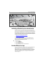
WAAS Satellite Differential GPS
WAAS provides differential augmentation to GPS. It was designed to
enhance the basic GPS service to satisfy the aviation industry’s
navigation requirement for instrument flight rule navigation and
landing, IFR and approach landings. WAAS has been in near
continuous broadcast since December 1999 and is also available for
other GPS applications such as marine navigation, surveying,
agriculture and automotive systems.
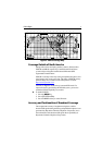
WAAS consists of a network of ground reference stations across the
United States that monitor GPS satellite data. The master stations
collect data from the reference stations and create a GPS correction
message, taking into account selective availability (SA), GPS
satellite orbit and clock drift, and signal delays caused by the
atmosphere and ionosphere. The ‘corrected’ differential messages
are then broadcast through two Geostationary Earth Orbit (GEO)
satellites on the same frequency as the GPS signal. The Raymarine
Raynav 300 and 301GPS receiver utilizes one of its 12 channels to
‘listen’ and decode the corrected WAAS messages. The result is a
DGPS system that provides improved accuracy (<3 meters) in
comparison with standard GPS (100 meters with SA, 15 m without
SA) and land based DGPS (10 meters) systems.
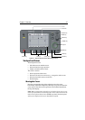
The WAAS system is shown diagrammatically in Figure i.