


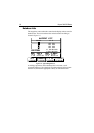

1-4 Raynav 300 GPS Plotter
• Man OverBoard (MOB) to navigate back to a missing person or
object
• Data Log display
For systems with an autopilot, when the status and locked heading
information change, the new data can be displayed.
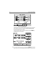
GPS Data Pages
Amongst a number of information pages, the GPS Data pages provide a
series of four textual displays, selected by the associated soft key. These
provide essential information associated with plotting a course for your
vessel.
•Fix status
• Steering Indication
• Position Latitude/Longitude
• Waypoint Bearing and Range
• Course Over Ground (COG)
• Speed Over Ground (SOG)
• Current Time
• Sunrise and Sunset Times
• Twilight Times
The range of pages is detailed in Selecting the Display Mode on page 2-4.
The complete range of pages is described fully in Data Display Pages on
page 3-2.
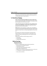
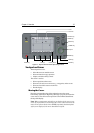
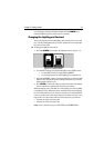
1.4 Operating Controls
Operation utilizes a number of buttons and on-screen controls. These
include:
• A trackpad providing up, down, left, right and diagonal control of an
on-screen cursor.
• Eight dedicated (labelled) control keys.
• Four soft keys with labels displayed on screen.
• Pop-up menus, displayed on-screen, from which options are selected.
• Database lists, displayed on-screen, which enable editing of items.
Note: The cursor is the cross-hair symbol (+) visible on the display. The
trackpad moves the cursor to select a position or item on the chart.
The controls are shown in Figure 1-1. They are back-lit for night-time
use. When you use certain controls, a help message is displayed at the top
of the screen (unless you switch help off as described in Chapter 4). The
following paragraphs describe the controls and on-screen facilities.