


1-2 Raynav 300 GPS Plotter
1.2 Features
General
The Raynav 300 GPS Plotter has a built-in GPS that provides the
following navigational signals:
• Satellite Differential GPS (eg, WAAS).
• Ground based Differential GPS, when used with an additional RTCM
beacon receiver.
• Standard GPS.
These are listed in order of accuracy and their availability is dependent
upon your location. The Raynav 300 GPS Plotter uses the best available
signal to provide optimum accuracy.
The Raynav 300 GPS Plotter is waterproof to CFR46 and can be installed
either above or below deck.
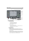
The unit comprises
• Low profile antenna
•4
½ in. LCD display comprising:
• Eight dedicated (labelled) control keys
• Four soft keys with labels displayed on-screen
•Trackpad
The display and keys can be illuminated for night-time use.
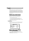
Display
• Computes position information from SDGPS, DGPS or GPS
• Displays and transmits SeaTalk and NMEA data
• Cursor echo across SeaTalk
• Choice of orientation: Head Up, Course Up and North Up
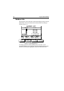
Display Modes
The GPS Plotter can display data in the following modes,
cycled through by means of the
DISPLAY key:
• Default GPS/Waypoint display
• Boat Data (three pages) / Environment Data (two pages)
• Bearing & Distance Indicator (BDI) / Course Deviation Indicator
(CDI)
• Data Boxes
• Data Log
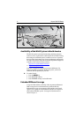
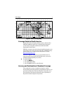
• Plotter display
• Return to default GPS/Waypoint display