


4-10 Raynav 300 GPS Plotter
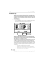
• North Up: The screen is displayed with north upwards. As you
change heading, the ship’s heading marker moves. This is the default
mode and is the only mode available if there is no heading data.
• Course Up: The plotter is stabilized and displayed with the currently
selected course upwards. If you select a new course, the picture
rotates to display the new course upwards.
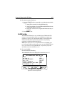
The reference used for the Course Up depends on the information
available. The first available in the following is used:
• A locked heading over a SeaTalk connection
• The heading at the time Course Up was selected
To update the Course Up reference whilst Course Up is the current
mode, re-select Course Up from the set up menu.
• Head Up: The display shows the vessel’s current heading upwards.
As the heading changes the image will rotate.
Waypoint Symbols
This setting controls whether or not the waypoints are shown on the
display, with their appropriate symbols. The active waypoint, and
waypoints in the current route, are always shown.
Waypoint Numbers
This setting controls whether or not the waypoint numbers are shown for
any waypoints in the current route.
Default Waypoint Symbol
This setting provides a selection of symbols for the default waypoint
display.
Vectors
Heading, Tide and Course Over Ground vectors can be displayed as a line
from your vessel. The length of the vector is determined by your choice of
SOG and the time period. An infinite vector extends to the edge of the
screen.
• Heading Vector indicates your current heading.
• COG Vector indicates your course over ground.
• Tide Vector indicates the tide set. Tide information is calculated from
the speed through water, compass heading plus COG and SOG.