Use the up down arrow to highlight the route about which you wish to receive more information.
Press ENTER when the selection is correct. Additional information will be displayed, including all
waypoints in the route and the total distance of the route. Press SELECT to exit.
Use the up/down arrows to highlight another route or press SELECT to go to the ROUTE menu.
Press SELECT again to exit to the MAIN MENU. Pressing SELECT a third time will exit the
Select System and return to the map. Or you may press MAP, at any time while in the Select
System, to return directly to the map display.
Distance Function
There are two ways to use the distance function. The distance from your present position
to your cursor position is automatically displayed in the multi-use display box, but if you want to
know the distance and bearing between two points other than your present position you can use:
1. The cursor with the DIST key or,
2. The PICK with the DIST key
Using the Cursor with the DIST Key
Press CLEAR to remove any existing modes from the mode indicator area.
Press the cursor arrow to lead you to the point that you want to know the distance from.
Press DIST You will notice a DIST mode indicator appearing in the lower part of the graphics
area.
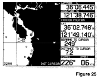
Press the cursor arrows to lead you to the point that you want to know the distance to. The multi-
use display box will indicate the bearing and distance between the first point and the cursor
position (Refer to Figure 25).
Note: If you use the cursor to identify the first point for the DIST function, then you must continue
using only the cursor.
Using the PICK Key with the DIST Key
Press CLEAR to remove any existing modes from the mode indicator area.
You must first identify the point you want to know the distance from.
Press DIST The cursor prompt will be displayed.
Press the arrow that best corresponds to the direction of the desired existing waypoint, until the
desired waypoint is picked.
