


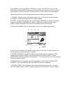
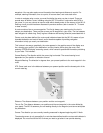
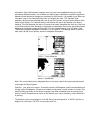
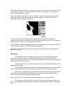
information. Figure 29 illustrates a sample route you may have established using one of the
techniques discussed earlier, and includes your starting point, destination, and two waypoints in
between where directional changes are necessary to avoid terrain. It is possible to use either the
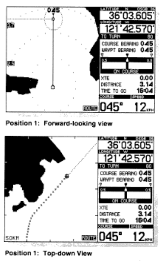
"top-down" view, or the "forward looking view" to navigate this route. The "top-down view"
provides a bird's eye view oriented with north at top of the screen, and your boat's position at the
center of the display. The "forward looking" view orients the map to the direction your boat is
traveling. This view presents the map in a manner that closely resembles the view out of the front
of your boat and can make following a route easier to understand. Each of the associated screen
displays on the following pages show the NS 10 in the "forward-looking" and "top-down" view.
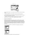
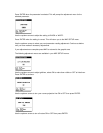
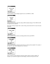
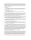
The following displays correspond to positions 1-5 in Figure 29. The steering screen is active in
each case, as this is your primary source of navigation information.
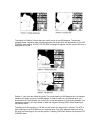
Note: The course history line is displayed when in the route mode if the route mode was turned
on through the Select System.
Position 1, your boat is on-course. Your boat's course is 045 degrees, and the course bearing for
this leg is also 045 degrees. If these two numbers are the same, you will remain on-course. Your
boat's heading (as shown on the boat's compass) may differ somewhat from the course due to
wind or current. Remember that course is the direction your boat is travelling, not the direction it
is pointing.
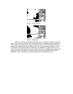
The distance to the next waypoint is 3.14 KM. Since your boat speed is 12.0 KPH, the time to
waypoint is 16 minutes. The XTE or cross track error is 0.