


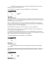
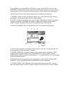

Use the up/down arrows choose ON or OFF then press ENTER.
The MAP OFFSET Menu allows you to accommodate localized regions where there is a
persistent offset in the map with respect to your present position. The offset is due to a shift in the
data base used to generate the digitized maps. Entering an offset distance and direction with
respect to your present position will move the map to the correct position. The latitude and
longitude of your present position and waypoints will not change. To determine the map offset
distance and direction, position your boat near a distinguishable coastline feature. Move the
cursor to the correct position on the map and record the distance and direction to the cursor. The
direction of the map offset will be in the opposite direction (180° difference) from the bearing to
the cursor. For example, if the bearing to the cursor is 340°, the map offset would be 160°. You
should do this for multiple points to ensure that the map offset to be entered is correct. Caution
should be observed when using this feature. You must first determine where the offset is
appropriate. Typically, this will be a localized region, usually in an offshore area like a group of
islands. When navigating outside this region it is also important to know where to turn the offset
off.
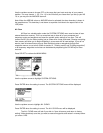
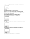
Use the keypad to enter the distance of the map offset in the unit of measurement you chose in
the System Options menu (statute miles, nautical miles or kilometers). Press ENTER when the
setting is correct.
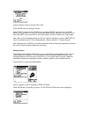
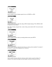
Use the keypad to enter the direction of the map offset then press ENTER.
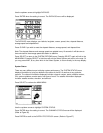
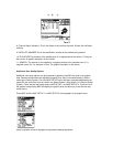
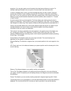
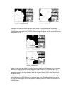
When the map offset is turned on the distance and direction will be displayed in the graphic
display area as shown below.