


Page 47CPV550
7.6 CUSTOMIZING THE SOFT KEYS
The Soft Keys can be individually customized from the default pages (discussed above) to
the following: CHART, CHART/COMPASS, CHART/HIGHWAY, NAVIGATION, HIGH-
WAY, CELESTIAL, GPS STATUS, NMEA DISPLAY, NMEA DATA, DEPTH TREND,
WIND SPEED TREND, TEMP TREND, SOG TREND, MARKS/WAYPOINTS and
USER C-CARD.
When the Optional FF520 50/200kHz BLACK BOX FISH FINDER is connected, any Soft
Key can be customized to show 50 or 200kHz full page, 50 or 200kHz Chart/Fish split screen
and zoom screens.
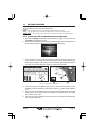
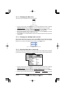
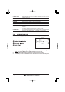
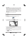
Figure 7.6 - Window options of the selected Soft Key
1. To change, select the chart page and momentarily press any of the Soft Keys, then press
and hold the Soft Key you want to customize.
2. A popup window will be shown with the above settings.
3. Move the ShuttlePoint knob up or down to select the desired page.
4. Press [ENT] or move the ShuttlePoint knob to the right to save the page to the selected
Soft Key.
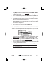
7.7 OTHER SETTINGS IN GENERAL SETUP MENU
You will notice the GENERAL SETUP menu has other selections that allow you to customize:
TIME SETUP Selects a submenu to allow the time setup. It is possible to set the GPS Time Offset,
choosing the UTC or Local Time display, and the Time Format, switching 12 or 24 hours
time format.
DATE FORMAT Allows choosing date format MM-DD-YY or DD-MM-YY.
COURSE UP/NORTH UP Selections are: North Up where the Top of the page is fixed to North and Course Up
where the top of the page is orientated to the direction the vessel is heading.
KEYPAD BEEP Allows the beep produced when a key is pressed to be turned on or off.
UNITS OF MEASURE Units of Measure can be selected for Distance, Speed, Depth, Altitude and Temperature.
NAV AIDS PRESENTATION Allows the Nav Aids presentation to drawn using NOAA symbology when US is selected
or International symbols will be used when International is selected. When selected these
functions affects how the icons for Lights, Signals, Buoys and beacons are displayed.
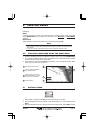
DISPLAY COLOR Changes the background colors of the chart page to enhance the visibility of the screen
depending on the surrounding light conditions. Normal is recommended when the GPS
Chart Plotter is not exposed to the direct sunlight. When this mode is set the maps are
displayed in order to use colors as similar as possible to ones used in the original paper
charts. Classic uses vivid chart colors presentation. NOAA allows setting NOAA paper
chart colors presentation. Night is recommended when the environment is dark in order
to reduce the glare of the display. The GPS Chart Plotter displays maps and screen in
darker colors. Sunlight is designed to enhance the visibility of the screen when the GPS
Chart Plotter is exposed to sunlight. The maps are much brighter than in the other modes
and the depth areas are filled with the white color so different depth areas not easily
distinguishable.
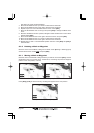
SHIP ICON Allows selection of one of 5 choices of ship icons that represent you vessels position
shown on the chart page.