


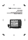

Page 8 CPV550
1.0 GENERAL INFORMATION
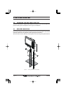
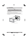
The GPS Chart Plotter is a precision-crafted, high-performance receiver for the Global
Positioning System (WAAS GPS) constellation of satellites, providing precise location data
with a host of navigation features. Ideal for nautical use and sealed against water ingress.
The GPS Chart Plotter is housed in a rugged, impact-resistant case with outstanding
ergonomic design, for effortless operation.
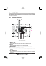
GPS Chart Plotter features include:
y 12-inch 256-Color TFT sunlight viewable LCD display (Screen Resolution: 800x600)
y Capable of using optional Radar domes and open array's
y C-MAP NT
+
/MAX cartography compatible
y Improved Worldwide background showing C-MAP NT
+
/MAX detail up to 2.0 NM
y 16 Channel GPS WAAS Smart antenna, bracket and flush mounting hardware
included
y 3000 Waypoints (Marks) / 50 Routes storage
y User selectable data fields
y NMEA Data pages
y 4 NMEA Outputs and 4 Inputs
y 3 year limited warranty, lifetime flat rate
Marine VHF features include:
y Commercial grade ITU Class D VHF transceiver
y Complete Digital Selective Calling (DSC).
y Position request and send functions
y CLEAR VOICE noise reduction microphone with 16/9 key and channel selection
y Tri-station capability (RAM+ and/or VH-310 required)
y 30W loud hailer with listen back, 4 foghorns, bells, and whistles
y Oversized rotary channel selector
y Channel name capability
y User Programmable Scan, Priority Scan, and Dual Watch
y Fully adjustable backlighting and LCD contrast
y Voice scrambler (optional)