


1. RADAR OPERATION
1-78
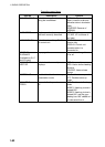
Nav data menu description
Item Description
2 DEPTH Selects unit of depth measurement, or turn depth indication off.
3 DEPTH
GRAPH SCALE
Selects depth scale range. The echogram shows the last 30 minutes of
sounding along the ship’s track.
4 DEPTH MARK Selects the depth at which to show the depth mark.
5 CURRENT Turns ocean current display on (ocean current relative to North) or off.
6 WIND Selects unit of wind speed measurement/wind speed format. Wind vector
format can be selected from three choices:
RELATIVE: Apparent wind measured by wind meter, with ship's bow as
reference.
TRUE THEORETICAL: Apparent wind minus ship's movement, with ship's
bow as reference.
TRUE NORTH: Apparent wind minus ship's movement, with North as
reference.
7 TEMP Turns water temperature indication on/off.
8 DATE-TIME Selects how to display date and time: OFF, UTC or LOCAL.
9 LOCAL TIME
ADJ
If LOCAL is selected at 8 DATE-TIME, roll the scrollwheel to set the time
difference between local time and UTC time. A negative value may be
selected by spinning the scrollwheel past zero.
0 WPT DATA Turn waypoint data off or select waypoint data reference, true or relative.
4. Push the right button twice to close the menu.
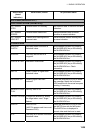
Note: Wind and current data require appropriate sensors. Depth data requires
appropriate echo-sounding equipment. Wind vector shows a direction from
which the wind blows in, relative to own ship heading, and labeled "T *." Wind
velocity is a true wind speed as a result of compensating for own ship’s speed
and orientation. Ocean current (tide) is shown relative to bow in head-up, cursor
gyro and course-up, and reference to North in north-up and true motion.
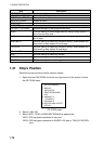
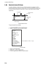
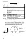
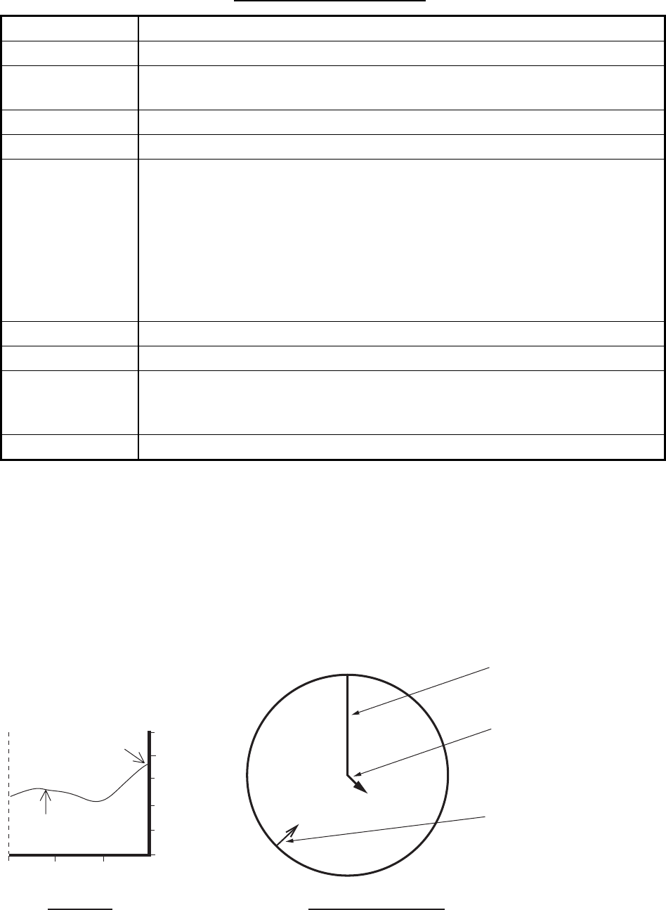
30
20 10 min
100 m
80
60
40
20
0
Present depth
Last 30 minutes
of depth
N
E
W
S
OS heading
Wind direction indication
method depends on the
MENU Selection of Wind
Vector.
Echogram
Wind, current graph
Current relative to north,
full scale 10 kn.
Examples of depth echogram and wind, tide graph