


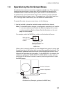


1. RADAR OPERATION
1-14
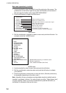
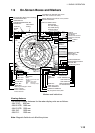
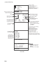
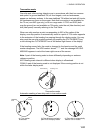
Guidance Box
TT, AIS Functions Box
TT TARGET
No. 42
BRG 25.5°T
RNG 3.4NM
R COG 264.0°T
R SOG 12.3KN
CPA 2.9NM
TCPA 12.2MIN
BCR 1.7NM
BCT 20MIN
20
40
60
80
100
-30 20 10
DEPTH 22.30 m
HDG
242.2°T
SPD
9.9kn BT
SB
0.1kn
COG
30.2°T
SOG
10.2.2kn
OS POSN
34°40.00N
135°24.00E
DGPS
Wind Speed and Angle*
(True or Relative angle)
Electronic Position-fixing
System and position*
Heading is TRUE
(variation-corrected gyro or
magnetic heading)
Speed data is LOG, MAN, etc.,
showing sensor and types.
TT Target Data
(See Chapter 3.)
* GPS, DGPS,
PPS, RTK, FRTK,
DR. PPS, RTK
and FRTK require
GGA sentence.
Tide relative to North,
full scale 10 kn
Wind direction relative to
own ship heading
S
WE
N
Depth
Depth Echogram
(See section 1.41.)
Alert Box
Messages for sensor error,
system error, alarms and
warning.
See section 1.44 for details.
Current speed and direction*
Water temperature, TTG,
WPT no., range and bearing
to waypoint
Date, time
* Referenced to ship's heading
(relative) in head-up,
head-up TB and course-up.
Referenced to North (true) in
north-up and true motion.
For presentation mode
description, see section 1.12.
EPFS shall meet the requirements
of the IMO resolution MSC.112(73).
CURRENT 2.3kn 69.9
°R
TEMP 16°C TTG 00:00:00
WPT001 6.5NM 35.2°R
DATE OCT/25/03 10:00 UTC
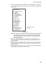
TT Target Data
(or Zoom)
Zoom display appears
in nav data box when
nav data is turned off.
WT
MAN
GPS
- - - - - SYSTEM ERROR - - - - -
VIDEO
- - - - - - - - - WARNING - - - - - - - -
FORMAT CARD DATA
TRUE 15.4 m/s
WIND 159.9
°
T
Data fields