


5. VIDEO PLOTTER OPERATION
5-8
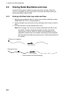
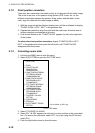
5.6 Radar Map Corrections
5.6.1 Radar map correction
When there is positional error between the radar screen and radar map marks
and lines, do the following to correct it.
1. With the cursor inside the effective display area, roll the scrollwheel to
display "CHART ALIGN L=OFF / EXIT" in the guidance box.
2. Operate the trackball to align the radar map with the radar screen.
3. Push the left button to set. "MAN ALIGNED" appears at the right side of the
screen.
To release the radar map correction, display "CHART ALIGN L=OFF / EXIT"
in the guidance box then push the left button until "MAN ALIGNED" disappears
from the screen.
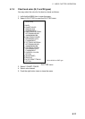
5.6.2 Cursor data correction
You can correct cursor data as below.
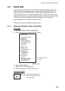
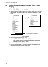
1. Left-click the MENU box to open the menu.
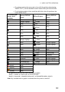
2. Select 5 [PLOTTER] to open the PLOTTER menu.
[PLOTTER]
1 BACK
2 CHART COLOR*
GRN/YEL/CYA
ORANGE/GRAY
3 OWN TRACK INTERVAL
OFF/DRAW/10S/30S/
1M/2M/3M/6M/15M
4 OWN TRACK COLOR*
RED/GRN/BLU/YEL/
CYA/MAG/WHT
5 TGT TRACK INTERVAL*
OFF/DRAW/10S/30S/
1M/2M/3M/6M/15M
6 TGT TRACK COLOR*
RED/GRN/BLU/YEL/
CYA/MAG/WHT
7 CURSOR L/L ALIGN
OFF/ON
8 [DATA ERASE]
9 [DISPLAY]
0 AUTO TARGET TRACK*
OFF/ON
* Not available on IMO type
PLOTTER menu
3. Select 7 CURSOR L/L ALIGN.