


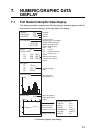
7. NUMERIC/GRAPHIC DATA DISPLAY
7-3
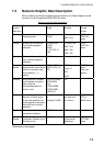
7.3 Numeric/Graphic Data Description
When a data is lost its last-entered value is shown in red. Data displays can be
turned on or off through the DATA DISPLAY menu.
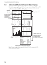
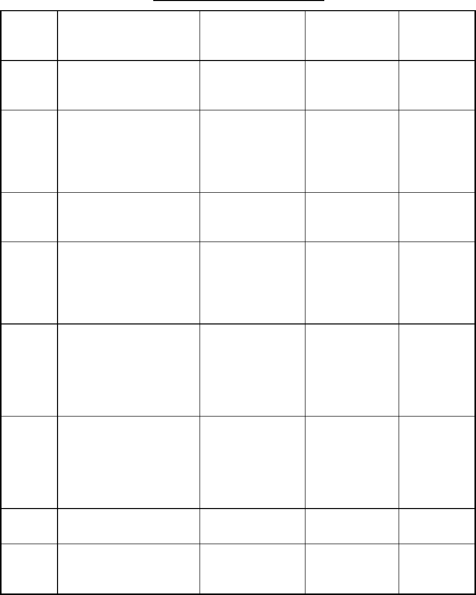
Numeric/graphic data description
Numeric/
graphic
data item
Description Display
range
Available
formats
Where to
change
format
Heading Shows heading input from
heading sensor.
32 comp. pts.
0-359°
32 comp. pts.
360° True
DATA
DISPLAY
menu
Course Shows ship’s course fed
from Numeric/graphic
indication.
32 comp. pts,
0-359°
0-359°
1-179° P/S, 0°,
180°
32 comp. pts.
360° True
360
° Rel
180
° Rel
DATA
DISPLAY
menu
Speed Shows ship’s speed fed
from a Numeric/graphic
indication.
0-40 kts Fixed at knots
Pos.
Sensor
Shows sensor which
inputs position data. When
there is no position data,
only brackets ([ ])
appear.
DPGS, KGPS,
FGPS, GPS, LC,
DR
GPS
Loran -C
DR
Auto
SYSTEM
menu
(See your
dealer.)
Position Ship’s position in latitude
and longitude. If position
data is lost the
last-entered position is
shown in red.
Lat: 90°00.000S-
90°00.000N
Lon:
179°59.999W-
179°59.999E,
180°00.00
L/L
Current Shows tide speed and
direction for three layers
or tide and speed for two
layers against a reference
layer fed from a current
indication.
Cur. Speed: 0-9.9
kt
Direction: 0-359
°
Direction shown
as “flow from,”
or “flow to.”
CURRENT
VEC &
WIND menu
Depth Shows depth from
transducer to bottom
0-9999m Meters
Net
Sonde
Depth of net sonde
transmitter. Shown only at
shooting of net.
0-999m Depth of up to
3 pts can be
displayed.
NET SONDE
SETTING
menu
(Continued on next page)