


55
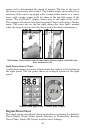
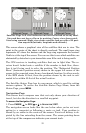
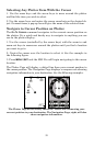
Satellite Page. Left view indicates unit has not locked on to any satel-
lites and does not have a fix on its position. Center view shows satel-
lites being scanned. Right view shows satellite lock-on with a 3D posi-
tion acquired (latitude, longitude and altitude.)
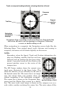
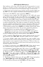
This screen shows a graphical view of the satellites that are in view. The
point in the center of the chart is directly overhead. The small inner ring
represents 45° above the horizon and the large ring represents the horizon.
North is at the top of the screen. You can use this to see which satellites are
obstructed by obstacles in your immediate area if the unit is facing north.
The GPS receiver is tracking satellites that are in light blue. The re-
ceiver hasn't locked onto a satellite if the number is dark blue, there-
fore it isn't being used to solve the position. The "Estimated Position
Error" (horizontal position error) shown in the upper left corner of the
screen is the expected error from a benchmark location. In other words,
if the EPE shows 50 feet, then the position shown by the unit is esti-
mated to be within 50 feet of the actual location.
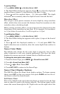
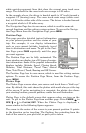
The Satellite Status Page has its own menu, which is used for setting
various options. To access the Satellite Status Page Menu, from the
Status Page, press
MENU.
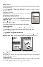
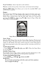
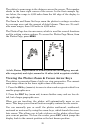
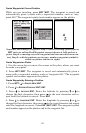
Navigation Page
This screen has a compass rose that not only shows your direction of
travel, but also the direction to a recalled waypoint.
To access the Navigation Page:
1. Press PAGES|← to GPS|↑ or ↓ to NAVIGATION|EXIT.
The navigation screen looks like the one below when you're not navi-
gating to a waypoint or following a route or trail. Your position is
shown by an arrow in the center of the screen. Your trail history is de-
picted by the line extending from the arrow. The arrow pointing down
at the top of the compass rose indicates your current track.