


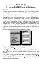
84
Map Fix
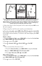
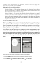
Map Fix is used with charts or maps. This system asks for a reference
position in latitude/longitude, which you take from a marked location
on the map. It then shows the present position as distance on the map
from that reference point.
For example, if it shows a distance of UP 4.00" and LEFT 0.50", you
then measure up four inches and to the left a half-inch from the refer-
ence point on the map to find your location.
To configure a map fix:
1. Take your map of the area and determine a reference lati-
tude/longitude.
NOTE:
Please note that in order for this system to work, the lati-
tude/longitude lines must be parallel with the edge of the map.
USGS maps are parallel, others may not be. Also, this works better
with smaller scale maps.
2. Once you have picked a reference position, save it as a waypoint. Press
EXIT repeatedly to return to the main display.
3. Press
MENU|MENU|↓ to GPS SETUP|ENT.
4. Press ↓ to
COORDINATE SYSTEM|ENT.
5. Press ↓ to
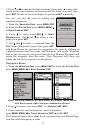
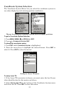
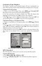
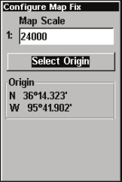
SETUP MAP FIX|ENT. The following screen appears with MAP
SCALE is highlighted.
6. Press
ENT and enter the map's scale. This is
generally at the bottom of the paper map. It's
shown as a ratio, like 1:24000.
7. Press
EXIT and the unit returns to the
Configure Map Fix screen.
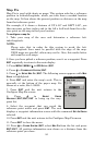
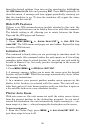
8. Press ↓ to
SELECT ORIGIN
WAYPOINT|ENT|ENT|ENT to bring up the way-
point list.
9. Select the waypoint that you saved the
reference point under and press
ENT. The unit
displays a waypoint information screen with the command
SET AS ORIGIN
selected.
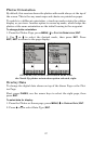
10. Press
ENT and the unit returns to the Configure Map Fix menu.
11. Press
EXIT to close the menu.
12. Press ↑ to
COORD SYSTEM|ENT, select MAP FIX from the list and press
ENT|EXIT. All position information now shows as a distance from the
reference point you chose.