


61
Find Distance between Points
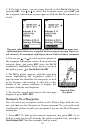
1. While on the Plotter Page press: MENU|↓ to FIND DISTANCE|ENT.
2. Center your cursor over the position you want to find the distance to.
A rubber band line appears, connecting your current position to the
cursor's location. The distance along that line will appear in the infor-
mation box at the bottom of the screen.
3. Press
EXIT to return to regular operation.
Cancel Navigation
You can turn off any of the navigation commands after you reach your
destination or at any other time by using the Cancel Navigation com-
mand.
To cancel navigation:
Press MENU|MENU|↓ to CANCEL NAVIGATION|ENT|← to YES|ENT.
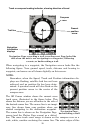
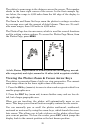
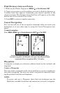
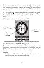
At left, the distance from the boat's current position to
nearest waypoint is 3.20 miles. At right. the distance from
waypoint 003 to waypoint 009 is 7.94 miles.
Waypoints
A waypoint is simply an electronic address based on the latitude and
longitude.
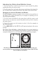
Create a Waypoint
You can create a waypoint at the cursor position or at your current posi-
tion while navigating. You also can create a waypoint by manually enter-
ing the position's latitude and longitude.
NOTE:
To create and save a Waypoint, these first two techniques use the
Quick Save method, the fastest and easiest way to create a waypoint.