


67
Navigate Back to MOB Waypoint
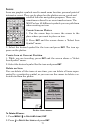
Find your way back to the accident position with the Navigation Page
or Plotter Page. When MOB is activated, the Navigation Page auto-
matically shows the compass rose with its bearing arrow pointing to-
ward the man overboard position.
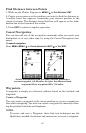
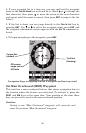
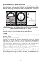
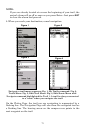
Navigating to Man Overboard: Navigation Page, left and center, and
Plotter Page, right. The victim is astern of the vessel; the GPS shows
which direction to steer to for the rescue.
The man overboard position is stored in the waypoint list for future
reference. It can be edited the same as any other waypoint.
Trails
A trail, or plot trail, is a string of position points that record the path
you have taken.
Creating and Saving a Trail
The M52 Pro is set at the factory to automatically create and record a
trail while the unit is turned on. The unit will continue recording the
trail until the length reaches the maximum trail point setting (default is
2,000, but the unit can record trails 9,999 points long). When the point
limit is reached, the M52 Pro begins recording the trail over itself.
With the default auto setting, the M52 Pro creates a trail by placing a dot
(trail point) on the screen every time you change directions.
To preserve a trail from point A to point B, you must "turn off" the trail
by making it inactive before heading to point C or even back to point A.
When the current trail is set inactive, the M52 Pro automatically be-
gins recording a new trail.