


2
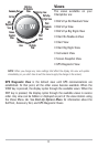
The following GPS functionality is currently supported by the 700 Series™
Chartplotter when it is connected to the included GPS receiver:
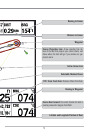
• View current position
• View current track (breadcrumb trail)
• View precision speed and heading from your GPS receiver
• Save tracks, waypoints and routes
• Travel a route and navigate from one waypoint to the next.
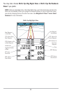
Your 700 Series™ supports Navionics® Gold, HotMaps™ and HotMaps™ Premium
on MMC or SD card media.
NOTE: Your 700 Series™ does not support Navionics® Classic Charts, only Navionics® Gold,
HotMaps™, and HotMaps™ Premium.
Your unit also comes with a built-in UniMap™ with a more detailed map of
North America (Domestic models) or a more detailed map of Europe and
Southeast Asia, including Australia and New Zealand (International models).
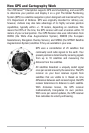
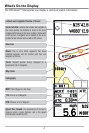
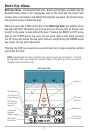
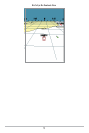
Your 700 Series™ uses the GPS Receiver to determine the position of the boat
automatically, and uses the zoom level settings on a particular view to select
the best chart to display. See Viewing Cartography for more information.