


4
What’s On the Display
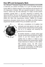
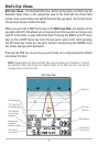
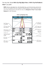
The 700 Series™ Chartplotter can display a variety of useful information.
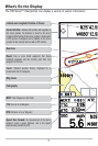
Cursor Info Box: indicates the Latitude and Longitude of
the cursor position, the distance to travel to the cursor
position and the bearing to the cursor position is shown with
a GPSreceiver. A waypoint can be marked at the cursor
position for later retrieval and use with a GPS receiver.
Boat Icon
Latitude and Longitude Position of Cursor
Map Scale
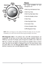
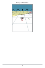
Route: Two or more linked waypoints that show
intended navigation and the shortest path from one
waypoint to the next.
Track: Detailed position history, displayed as a
breadcrumb trail of trackpoints.
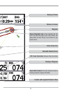
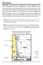
Speed Over Ground: the measurement of the boat’s
progress across a given distance, and is the speed
measurement provided by GPS.
DTG: Distance to Go to Waypoint
Cartography
NEXT: Next Waypoint in the Route
TTG: Time to Go to Waypoint