


GPSMAP
®
6000/7000 Series Owner’s Manual 11
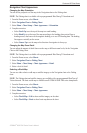
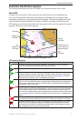
Charts and 3D Chart Views
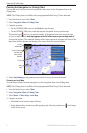
Navigation Chart Appearance
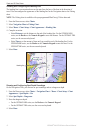
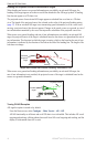
Changing the Map Orientation
You can set the perspective of the map in the Navigation chart or the Fishing chart.
NOTE: The Fishing chart is available with a preprogrammed BlueChart g2 Vision data card.
1. From the Home screen, select
Charts.
2. Select
Navigation Chart or Fishing Chart.
3. Select
Menu > Chart Setup > Chart Appearance > Orientation.
4. Complete an action:
Select North Up to set the top of the map to a north heading.
Select Head Up to set the top of the map according to the heading data received from a
heading sensor, also known as the magnetic heading, or to use GPS heading data. The heading
line appears vertically on the screen.
Select Course Up to set the map so the direction of navigation is always up.
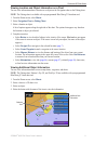
Changing the Map Zoom Detail
You can adjust the amount of detail shown on the map, at different zoom levels, for the Navigation
Chart or the Fishing Chart.
NOTE: The Fishing chart is available with a preprogrammed BlueChart g2 Vision data card.
1. From the Home screen, select
Charts.
2. Select
Navigation Chart or Fishing Chart.
3. Select
Menu > Chart Setup > Chart Appearance > Detail.
4. Select a level of detail.
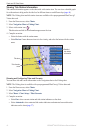
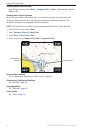
Selecting a World Map
You can use either a basic world map or satellite imagery on the Navigation chart or the Fishing
chart.
NOTE: The Fishing chart and satellite imagery are available with a preprogrammed BlueChart g2
Vision data card. The basic world map is available on all GPSMAP 6000/7000 series chartplotters.
1. From the Home screen, select
Charts.
2. Select
Navigation Chart or Fishing Chart.
3. Select
Menu > Chart Setup > Chart Appearance.
4. Complete an action:
Select World Map > Full to show satellite imagery on the chart.
Select World Map > Basic to show basic map data on the chart.
•
•
•
•
•