


66 GPSMAP
®
6000/7000 Series Owner’s Manual
Device Conguration
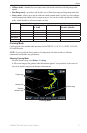
Conguring the Appearance of Other Vessels
NOTE: The Fishing chart and Mariner’s Eye 3D are available with a preprogrammed BlueChart g2
Vision data card.
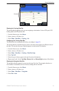
1. From the Home screen, select
Charts.
2. Select
Navigation Chart, Fishing Chart, Perspective 3D, or Mariner’s Eye 3D.
3. Select
Menu > Other Vessels > Display Setup.
4. Complete an action:
Select Display Range to indicate the distance from your location within which AIS vessels
appear. Select a distance.
Select MARPA > Show to show information about MARPA-tagged vessels.
Select Details > Show to show details about other vessels.
Select Proj. Heading to set the projected heading time for MARPA-tagged vessels. For the
GPSMAP 6000 series, use the Rocker or the Numeric Keypad to enter the heading. For the
GPSMAP 7000 series, use the on-screen keyboard. Select Done.
Select Trails to show the tracks of AIS vessels. Select the length of the track that appears
using a trail.
Information about Your Boat
Calibrating a Water Speed Device
If you have a speed-sensing transducer, you can calibrate that speed-sensing device.
1. From the Home screen, select
Congure > My Boat > Calibrate Water Speed.
2. Follow the on-screen instructions.
NOTE: If the boat is not moving fast enough or the speed sensor is not registering a speed, a
“Speed too low” message appears. Select OK, and safely increase the boat speed. If the message
appears again, stop the boat, and ensure that the speed-sensor wheel is not stuck. If the wheel
turns freely, check the cable connections. If you continue to get the message, contact Garmin
Product Support.
Setting the Fuel Capacity of Your Boat
1. From the Home screen, select Congure > My Boat > Fuel Capacity.
2. Enter the combined fuel capacity of all the engines on your boat:
For the GPSMAP 6000 series, use the Rocker or the Numeric Keypad.
For the GPSMAP 7000 series, use the on-screen keyboard.
3. Select
Done.
•
•
•
•
•
•
•