


GPSMAP
®
6000/7000 Series Owner’s Manual 21
Charts and 3D Chart Views
Showing and Conguring Data Bars
See “Data Bars” (page 62).
Using Waypoints and Tracks
See “Waypoints” (page 34) or “Tracks” (page 39).
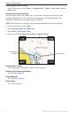
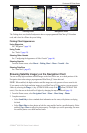
Radar Overlay
When you connect your chartplotter to an optional Garmin marine radar, you can use Radar Overlay
to overlay radar information on the Navigation chart or on the Fishing Chart (page 83).
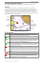
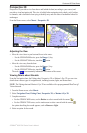
BlueChart g2 Vision
An optional, preprogrammed BlueChart g2 Vision data card allows you to get the most out of your
chartplotter. In addition to detailed marine charting, BlueChart g2 Vision has the following features:
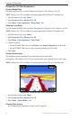
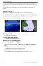
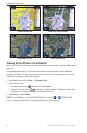
Mariner’s Eye 3D—provides a view from above and behind the boat for a three-dimensional
navigation aid. The BlueChart g2 Vision Mariner’s Eye 3D is more detailed than the pre-loaded
data (page 22).
Fish Eye 3D
—provides an underwater, three-dimensional view that visually represents the
sea oor according to the information on the chart (page 24).
Fishing Charts—shows the chart with enhanced bottom contours and without navigational data.
This chart works well for offshore deep-sea shing (page 24).
High Resolution Satellite Imagery—provides high-resolution satellite images for a realistic
view of the land and water on the Navigation chart (page 25).
Aerial Photos—shows marinas and other navigationally signicant aerial photos to help you
visualize your surroundings (page 26).
Detailed Roads and POI data
—shows roads, restaurants, and other points of interest (POIs)
along the shore (page 27).
Auto Guidance—uses specied safe depth, safe height, and chart data to determine the best
course to your destination (page 27).
BlueChart g2 Vision Data Cards
NOTICE
BlueChart g2 Vision data cards are not waterproof. When you are not using the card, keep it in
the original packaging for safekeeping and store it away from exposure to sun and rain to prevent
damage to the card.
BlueChart g2 Vision data cards are susceptible to damage from static electricity. In low-humidity
environments, you should ground yourself on a large metal object before handling the card to
prevent damage to the card.
You can share BlueChart g2 Vision cartography data from a data card inserted in one GPSMAP 6000
or GPSMAP 7000 series chartplotter with every GPSMAP 4000 series, 5000 series, 6000 series,
and 7000 series chartplotter connected to the Garmin Marine Network (page 116). BlueChart g2
Vision cartography is compatible only with GPSMAP 4000 series and later chartplotters. Previous
Garmin Marine Network-compatible chartplotter models (such as the GPSMAP 3000 Series) can be
connected to your network, but they cannot share BlueChart g2 Vision data.
•
•
•
•
•
•
•