GPSMAP
®
6000/7000 Series Owner’s Manual 47
Almanac, Environmental, and On-boat Data
Current Information
NOTE: Current station information is available with a BlueChart g2 Vision card.
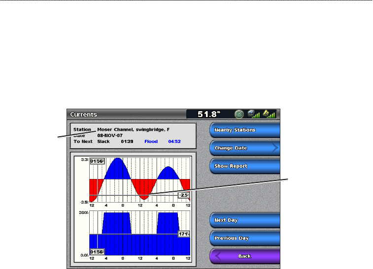
The Currents screen shows information about a current station for a specic date and time, including
the current speed and level. By default, the chartplotter shows current information for the most
recently viewed current station and for the present date and time.
From the Home screen, select Information > Tides/Currents > Currents.
Current Station Information
Current
station
Current level at
local time
Viewing Information about a Nearby Current Station
NOTE: Current station information is available with a BlueChart g2 Vision card.
1. From the Home screen, select
Information > Tides/Currents > Currents > Nearby Stations.
2. Select a station.
Conguring Current Station Information
You can indicate the date of current station information to be viewed, and you can view the
information in a chart or a report format.
NOTE: Current station information is available with a BlueChart g2 Vision card.
1. From the Home screen, select
Information > Tides/Currents > Currents > Nearby Stations.
2. Select a station.
3. Complete an action:
Select Change Date > Manual to view tide information for a different date. For the GPSMAP
6000 series, use the Rocker to enter the date. For the GPSMAP 7000 series, use the on-screen
keyboard. Select Done.
Select Show Report to view the Current Report for the selected station. The report includes
slack water, ood, and ebb levels.
Select Next Day to view current information for the day after the date shown.
Select Previous Day to view current information for the day before the date shown.
•
•
•
•


