


GPSMAP
®
6000/7000 Series Owner’s Manual 23
Charts and 3D Chart Views
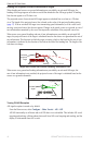
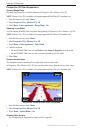
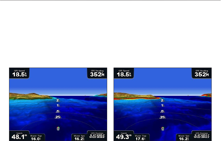
Showing or Hiding Hazard Colors
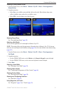
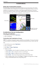
1. From the Home screen, select Charts > Mariner’s Eye 3D > Menu > Chart Appearance >
Hazard Colors.
2. Complete an action:
Select On to view shallow water and land with a color scale. Blue indicates deep water,
yellow is shallow water, and red is very shallow water.
Select Off to view the land as seen from the water.
Mariner’s Eye 3D, Hazard Colors Off Mariner’s Eye 3D, Hazard Colors On
Showing Range Rings
See “Showing Range Rings” (page 20).
Selecting a Safe Depth
You can set the appearance of a safe depth for Mariner’s Eye 3D.
NOTE: This setting effects only the appearance of hazard colors in Mariner’s Eye 3D. It does not
effect the safe water depth Auto Guidance setting (page 59) or the sonar shallow water alarm setting
(page 105).
1. From the Home screen, select
Charts > Mariner’s Eye 3D > Menu > Chart Appearance >
Safe Depth.
2. Complete an action:
For the GPSMAP 6000 series, use the Rocker or the Numeric Keypad to enter the depth.
For the GPSMAP 7000 series, use the on-screen keyboard to enter the depth.
3. Select
Done.
Selecting a Lane Width
See “Selecting a Lane Width” (page 20).
Showing Other Vessels
See “Conguring the Appearance of Other Vessels” (page 66).
Showing Surface Radar
See “Showing Surface Radar” (page 20).
Showing and Conguring Data Bars
See “Data Bars” (page 62).
Using Waypoints and Tracks
See “Waypoints” (page 34) or “Tracks” (page 39).
•
•
•
•