


5-1
5. ROUTES
5.1 What is a Route?
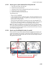
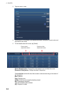
A route is a series of route points leading to a final destination. When you follow a
route, the equipment automatically switches route points and provides pertinent navi-
gation data.
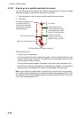
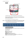
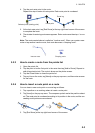
The equipment can store a maximum of 200 routes with a maximum of 500 points per
route. Inactive routes on the display are shown with the “sleeping route” icon, pictured
below, to keep the screen from getting too cluttered.
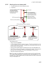
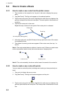
You create a route by selecting geographical positions on the screen. These positions
are marked with numbered circles. A route that is being used for navigation is called
the “active route”.
The current leg of the active route is shown as a red dashed line and all preceding legs
are shown in light gray.
The routes on the screen can be edited from the pop-up menu. The following editing
features are available:
• Insert route points in a route
• Move route points in a route
• Delete route points from a route
• Extend a route
• Split routes
• Find information about a route
• Delete a route
• Set a route as destination
• Follow a route in the reverse direction
• Ignore a route point when following a route
Note: Active routes can be shared with other NavNet TZtouch2 units via LAN. Data is
shared automatically; no operation is required.