


8-1
8. FILE OPERATIONS
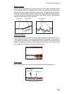
Points, tracks* and routes can be imported and exported and track can be exported,
using micro SD cards (w/SD card unit) or USB memory. (The card drive at the rear of
the display unit is for chart cards.)
* All points and routes are erased from the plotter display when tracks are imported.
Note: DO NOT remove an SD card while it is being accessed, to prevent loss of data
or damage to the card.
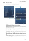
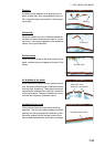
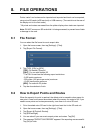
8.1 File Format
You can select the file format to use to export data.
1. Open the home screen, then tap [Settings] - [Files].
2. Tap [Export File Format].
3. Tap [TZD], [CSV] or [GPX].
[TZD]: For NavNet TZtouch2
[CSV]*: For use with NavNet 3D
* The CSV format has the following export restrictions:
- 2,000 points maximum
- 200 routes (100 points per route) maximum
- 10,000 track points maximum
[GPX]: For use with PC plotter
4. Tap the close button to finish.
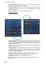
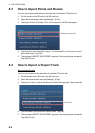
8.2 How to Export Points and Routes
When the capacity for point is reached, the oldest point is erased to clear space for
new point. A new route cannot be entered when the memory for routes is full. If you
need to save points and routes permanently, save them to a micro SD card.
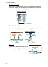
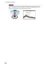
1. Put a formatted micro SD card in the right hand card slot in the SD card unit.
2. Open the home screen, then tap [Settings] - [Files].
3. Tap [Export All Points & Routes].
4. Tap [SDCardRight].
5. You are asked if you are sure to export points and routes. Tap [OK].
6. The message "EXPORT SUCCEEDED" appears if the exporting was successful.
Tap [OK] to finish.