


2. PLOTTER
2-23
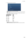
[Transparencies]
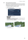
[NavData Transparency]: Set the degree of transparency for the navdata display.
[PhotoFusion Transparency]: Set the degree of transparency for the satellite photo
overlay.
[Tide Range for PhotoFusion]: Set the degree of transparency for the tide range in
the satellite photo overlay.
[Tidal Currents Transparency]: Set the degree of transparency for the tidal currents
display.
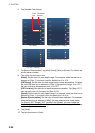
[Radar Overlay]
[Radar Transparency]: Set the degree of transparency for the radar echo.
[Range Link]: Activate or deactivate matching the overlay with radar ranges.
[Echo Color]: Tap the color for the radar echo.
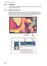
Depth Shading Values
[Depth Shading Transparency]: Set the degree of transparency for the depth shad-
ing overlay.
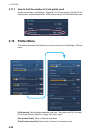
For the menu items shown in the table, see the mentioned section.
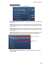
[Reset Default Settings]: Tap this menu item to restore default settings for the [Plot-
ter Display] menu.
Menu item Reference
[3D Display]
• [Auto 3D Alti Exaggeration]
• [3D Alti Exaggeration]
See paragraph 3.1.2.
[Depth Shading Values]
• [Auto Depth Shading Color Scale]
• [Minimum Value]
• [Maximum Value]
• [Depth Color Shade]
See paragraph 3.2.1.