


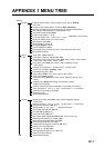


APPENDIX 1 MENU TREE
AP-3
Grid Interval (Off, Very Small, Small, Medium, Large, Very Large)
Show Scale Slider (OFF, ON)
Tide/Current Icons Size (50 - 150(%), 100)
NavData Transparency (0 - 80(%), 10)
PhotoFusion Transparency (0 - 80(%), 15)
Tide Range for PhotoFusion (0.0 - 60(ft), 0)
Tidal Currents Transparency (0 - 80(%), 25)
Radar Transparency (0 - 80(%), 20)
Range Link (ON, OFF)
Echo Color (Multicolor, Green, Yellow)
Depth Shading Transparency (0 - 80(%), 50)
Auto Depth Shading Color Scale (ON, OFF)
Minimum Value* (0000 - 33000(ft), 0)
Maximum Value* (00000 - 33000(ft), 200)
Depth Color Shade (Classic Hue, Inverted Classic Hue, Red Hue, Blue Hue,
Green Hue, Yellow Hue)
Auto Alti 3D Exaggeration (ON, OFF)
3D Alti Exaggeration (1 - 20, 3)
Reset Default Settings
Chart Object Size (50 - 200(%), 100%)
Chart Color Palette (S52, Standard, Sunlight)
Chart Symbols (S52, International)
Shallow Contour (0.0, 3.3, 6.6, 9.8, 13.1, 16.4, 19.7, 23.0, 26.2, 29.50, 32.8 (ft))
Safety Contour (0.0, 3.3, 6.6, 9.8, 13.1, 16.4, 19.7, 23.0, 26.2, 29.50, 32.8,
49.2, 65.6, 98.4, 164 (ft))
Deep Contour (0.0, 3.3, 6.6, 9.8, 13.1, 16.4, 19.7, 23.0, 26.2, 29.50, 32.8,
49.2, 65.6, 98.4, 164, 328, 656, 984, 1,640 (ft))
Text (Important) (ON, OFF)
Text (Other) (ON, OFF)
Display Buoy Names (ON, OFF)
Display Light Description (ON, OFF)
Display Light Sectors (ON, OFF)
Display Routes (ON, OFF)
Display Routes Bearings (ON, OFF)
Display Soundings (ON, OFF)
Display Soundings in Red (ON, OFF)
Obs. Depth Below Safety (ON, OFF)
Display Seabed (ON, OFF)
Cautionary Areas (ON, OFF)
Reset Default Settings
Shallower than... (0.0, 3.3, 6.6, 9.8, 13.1, 16.4,
19.7, 23.0, 26.2, 29.5, 32.8, 49.2, 65.6, 98.4(ft))
Plotter
1
1
* Auto Depth Shading
Color Scale OFF
Vector
Chart