


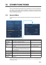

13. OTHER FUNCTIONS
13-3
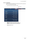
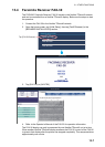
13.3 Initial Setup Menu
The [Initial Setup] menu, which is mainly for use by the installer of the equipment, sets
up the system according to the sensors connected. These adjustments require some
knowledge of marine electronics equipment. If you are unsure of your abilities, have a
qualified marine electronics technician make the adjustments. Inadequate adjustment
can affect performance.
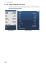
GPS POSITION section
BOAT INFORMATION section
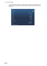
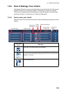
Graphic Instruments Setup:
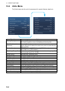
[Graphic Instruments Setup] - [Depth]
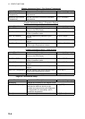
Menu item Description Options (setting range)
[Longitudinal (from
bow]
Enter the GPS antenna posi-
tioning bow-stern (Longitudi-
nal) and port-starboard
(Lateral) position from the
origin.
0 m to 999 m
[Lateral GPS Position
(-Port)]
-99 m to +9 m
Menu item Description Options (setting range)
[Boat Length] Set the length of your boat. 0.0 m to 999 m
[Size of Static Icon] Set the size of static (such as own ship)
icons.
50 to 150
[Depth Display] Select the start point for depth measure-
ment.
[Under Keel], [Under Sea Lev-
el]
[Transducer Draft] Set the transducer draft. 0.0 m to 99.9 m
[Keel Draft] Set the keel draft. 0.0 m to 99.9 m
[Graphic Instruments
Setup]
Set the graphic instruments display. See the description below.
[Engine & Tank Setup] Set the engine and tank displays. See “Engine & Tank Setup” on the next
page.
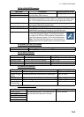
Menu Item Description Options (setting range)
[Maximum Boat Speed] Set the transducer’s maximum detectable
speed.
1 kn to 99 kn
[Maximum Wind Speed] Set the transducer’s maximum detectable
speed.
1 kn to 99 kn
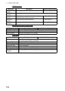
Menu Item Description Options (setting range)
[Minimum Depth] Set the transducer’s minimum detectable
depth.
1 m to 19 m
[Maximum Depth] Set the transducer’s maximum detectable
depth.
20 m to 2000 m
Origin
Origin