


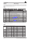
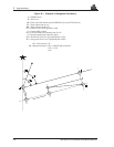

D Logs summary
162 MiLLennium Command Descriptions Manual
PRTKA/B Computed Position
(RTK)
This log contains the best available position computed by the receiver, along with three status flags. In addition, it
reports other status indicators, including differential lag, which is useful in predicting anomalous behaviour
brought about by outages in differential corrections.
This log replaces the P20A log; it is similar, but adds extended status information. With the system operating in
an RTK mode, this log will reflect the latest low-latency solution for up to 30 seconds after reception of the last
reference station observations. After this 30 second period, the position reverts to the best solution available; the
degradation in accuracy is reflected in the standard deviation fields, and is summarized in Chapter 1, Table 1-2. If
the system is not operating in an RTK mode, pseudorange differential solutions continue for 60 seconds after loss
of the data link, though a different value can be set using the
DGPSTIMEOUT command.
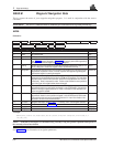
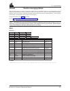
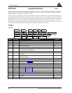
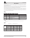
PRTKA
Structure:
$PRTKA week sec lag #sv #high
L1L2 #high lat lon hgt undulation datum ID
lat σ lon σ hgt σ soln status rtk status
posn type idle stn ID *xx [CR][LF]
Field # Field type Data Description Example
1 $PRTKA Log header $PRTKA
2 week GPS week number 872
3 sec GPS time into the week (in seconds) 174963.00
4 lag Differential lag in seconds 1.000
5 #sv Number of matched satellites; may differ from the number in view. 8
6 #high Number of matched satellites above RTK mask angle; observations from satellites
below mask are heavily de-weighted
7
7 L1L2 #high Number of matched satellites above RTK mask angle with both L1 and L2 available 7
8 lat Latitude of position in current datum, in decimal fraction format. A negative sign implies
South latitude
51.11358042429
9 lon Longitude of position in current datum, in decimal fraction format. A negative sign
implies West longitude
-114.04358006710
10 hgt Height of position in current datum, in metres above mean sea level 1059.4105
11 undulation Geoidal separation, in metres, where(+ve) is above ellipsoid and (-ve) is below ellipsoid -16.2617
12 datum ID Current datum (see Appendix G)61
13 lat σ Standard deviation of latitude solution element, in metres 0.0096
14 lon σ Standard deviation of longitude solution element, in metres 0.0100
15 hgt σ Standard deviation of height solution element, in metres 0.0112
16 soln status Solution status (see Table D-1) 0
17 rtk status RTK status (see Tables D-3, D-4) 0
18 posn type Position type (see Table D-2) 4
19 idle Percent idle time, percentage 42
20 stn ID Reference station identification (RTCM: 0 - 1023, or RTCA: 266305 - 15179385) 119
21 *xx Checksum *51
22 [CR][LF] Sentence terminator [CR][LF]