


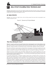

A GPS Overview
MiLLennium Command Descriptions Manual 55
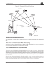
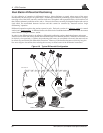
1. The matched position solution is computed at the remote station when the observation information for
a given epoch has arrived from the reference station via the data link. Matched observation set pairs
are observations by both the reference and remote stations which are matched by time epoch, and con-
tain the same satellites. The matched position solution is the most accurate one available to the operator
of the remote station, but it has an inherent latency – the sum of time delays between the moment that
the reference station makes an observation and the moment that the differential information is processed
at the remote station. This latency depends on the computing speed of the reference station receiver,
the rates at which data is transmitted through the various links, and the computing speed of the remote
station; the overall delay is of the order of one second. Furthermore, this position cannot be computed
any more often than the observations are sent from the reference station. Typically, the update rate is
one solution every two seconds.
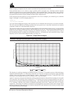
2. The low latency (or extrapolated) position solution is based on a prediction. Instead of waiting for the
observations to arrive from the reference station, a model (based on previous reference station observa-
tions) is used to estimate what the observations will be at a given time epoch. These estimated reference
station observations are combined with actual measurements taken at the remote station to provide the
position solution. Because only the reference station observations are predicted, the remote station’s
dynamics will be accurately reflected. The latency in this case (the time delay between the moment that
a measurement is made by the remote station and the moment that a position is made available) is de-
termined only by the remote processor’s computational capacity; the overall delay is of the order of 100
ms. Low-latency position solutions can be computed more often than matched position solutions; the
update rate can reach 4 solutions per second. The low-latency positions will be provided for data gaps
between matched positions of up to 30 seconds (for a carrier-phase solution) or 60 seconds (for a pseu-
dorange solution, unless adjusted using the DGPSTIMEOUT command). A general guideline for the
additional error incurred due to the extrapolation process is shown in Table 1-2.
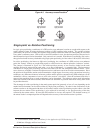
A.3.2 PSEUDORANGE ALGORITHMS
Pseudorange algorithms correlate the pseudorandom code on the GPS signal received from a particular satellite,
with a version generated within the reference station receiver itself. The time delay between the two versions,
multiplied by the speed of light, yields the pseudorange (so called because it contains several errors) between the
reference station and that particular satellite. The availability of four pseudoranges allows the reference station
receiver to compute its position (in three dimensions) and the offset required to synchronize its clock with GPS
system time. The discrepancy between the reference station receiver’s computed position and its known position
is due to errors and biases on each pseudorange. The reference station receiver sums these errors and biases for
each pseudorange, and then broadcasts these corrections to the remote station. The remote receiver applies the
corrections to its own measurements; its corrected pseudoranges are then processed in a least-squares algorithm to
obtain a position solution.
The “wide correlator” receiver design that predominates in the GPS industry yields accuracies of 3-5 m (SEP).
NovAtel’s patented Narrow Correlator technology reduces noise and multipath interference errors, yielding
accuracies of 1 m (SEP).
Pseudorange Differential Positioning
GPS SYSTEM ERRORS
In general, GPS SPS C/A code single point pseudorange positioning systems are capable of absolute position
accuracies of about 100 metres or less. This level of accuracy is really only an estimation, and may vary widely
depending on numerous
GPS system biases, environmental conditions, as well as the GPS receiver design and
engineering quality.
There are numerous factors which influence the single point position accuracies of any
GPS C/A code receiving
system. As the following list will show, a receiver’s performance can vary widely when under the influences of
these combined system and environmental biases.